
Science
Latest Earthquakes

Interactive mapper displaying any Puerto Rico earthquakes that have occurred in the last day.
Earthquake Hazards Program

The USGS monitors and reports on earthquakes, assesses earthquake impacts and hazards, and conducts targeted research on the causes and effects of earthquakes.
FAQs

Why/When does the USGS update the magnitude of an earthquake?
The USGS often updates an earthquake's magnitude in the hours and sometimes days following the event. Updates occur as more data become available for analysis and more time-intensive analysis is performed. Additional updates are possible as part of the standard procedure of assembling a final earthquake catalog. There are physical and operational constraints on how quickly seismic data are...
Where can I find current earthquake lists and maps for the world or for a specific area?
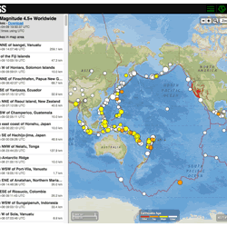
The Earthquake Hazards Program Latest Earthquakes Map displays earthquakes in near-realtime and up to the past 30 days of earthquakes. The interface includes three panels: a list of earthquakes, a map, and a settings/options panel. You can pan and zoom the map to view specific areas. Click on an event on the list or map for additional information and a link to the event page with all the details...

How quickly is earthquake information posted to the USGS website and sent out via the Earthquake Notification Service (ENS) and other feeds?
USGS earthquake information mechanisms are all triggered by the same system, so they all receive the information at the same time. The time it takes for the system to receive the information primarily depends on the size and location of the earthquake: An earthquake in California is processed and posted to the system in 2.5 minutes (on average). This is because our seismic network is very...