
Hurricane tracks for Hugo (1989), Georges (1998), Irma (2017) and Maria (2017). Data provided by NOAA. Base image is intellectual property of Esri and is used herein under license. Copyright Esri and its creator.
Multimedia
The USGS shares a wide range of resources to help assess, quantify and reduce risk. These multimedia resources can help you learn more about the many ways our science supports a stronger and more resilient Nation.
Images

Hurricane Tracks, Puerto Rico
Hurricane tracks for Hugo (1989), Georges (1998), Irma (2017) and Maria (2017). Data provided by NOAA. Base image is intellectual property of Esri and is used herein under license. Copyright Esri and its creator.

Debris flow after the 2003 Old Gran Prix fire
Damage from a major post-wildfire landslide that occurred on 25 December 2003 near Devore, San Bernardino County as a result of the Old/Grand Prix fires that ran through the San Bernardino Mountains.
Damage from a major post-wildfire landslide that occurred on 25 December 2003 near Devore, San Bernardino County as a result of the Old/Grand Prix fires that ran through the San Bernardino Mountains.

Home damaged by post-wildfire debris flow in Montecito, CA.
Damage from a major post-wildfire landslide that occurred on 9 January 2018 near Montecito, Santa Barbara County as a result of the 2017 Thomas Fire.
Damage from a major post-wildfire landslide that occurred on 9 January 2018 near Montecito, Santa Barbara County as a result of the 2017 Thomas Fire.

USGS and NBRO Scientists in Sri Lanka
USGS scientists collaborate with Sri Lankan scientists from the National Building Research Organization (NBRO) on the installation of rainfall and soil moisture instrumentation on an active landslide in southwest Sri Lanka. The station provides real-time data including rainfall and soil moisture content of an active landslide.
USGS scientists collaborate with Sri Lankan scientists from the National Building Research Organization (NBRO) on the installation of rainfall and soil moisture instrumentation on an active landslide in southwest Sri Lanka. The station provides real-time data including rainfall and soil moisture content of an active landslide.

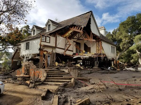
Montecito home damaged by post-wildfire debrisflow.
Damage from a major post-wildfire landslide that occurred on 9 January 2018 near Montecito, Santa Barbara County as a result of the 2017 Thomas Fire.
Damage from a major post-wildfire landslide that occurred on 9 January 2018 near Montecito, Santa Barbara County as a result of the 2017 Thomas Fire.
Videos

HayWired Scenario - Movie
The HayWired earthquake scenario, led by the U.S. Geological Survey (USGS), anticipates the impacts of a hypothetical magnitude-7.0 earthquake on the Hayward Fault.
The HayWired earthquake scenario, led by the U.S. Geological Survey (USGS), anticipates the impacts of a hypothetical magnitude-7.0 earthquake on the Hayward Fault.

ARkStorm
The ARkStorm scenario led by the USGS and hundreds of scientists and experts from many disciplines details impacts of a scientifically plausible storm similar to the Great California Storm of 1862 in the modern day.
The ARkStorm scenario led by the USGS and hundreds of scientists and experts from many disciplines details impacts of a scientifically plausible storm similar to the Great California Storm of 1862 in the modern day.

Preparedness Now
This film depicts the realistic outcome of a hypothetical, but plausible, magnitude 7.8 earthquake on the San Andreas fault in Southern CA.
This film depicts the realistic outcome of a hypothetical, but plausible, magnitude 7.8 earthquake on the San Andreas fault in Southern CA.