
Screen shot visualization of wind direction and velocity from a coupled/fire atmosphere model run of a wildfire (Dude Fire).
Images
Images intro.
Filter Total Items: 51

Modeling to Support Proactive Approaches to Wildland Fire
Screen shot visualization of wind direction and velocity from a coupled/fire atmosphere model run of a wildfire (Dude Fire).

Screenshot of USGS Wildfire Hazard and Risk Assessment Clearinghouse
Screenshot of the USGS Wildfire Hazard and Risk Assessment Clearinghouse. The clearinghouse provides a description and information about the spatial extent, resolution, fire modeling approach, values considered (assets and resources), and vintage of LANDFIRE and fire dat
Screenshot of the USGS Wildfire Hazard and Risk Assessment Clearinghouse. The clearinghouse provides a description and information about the spatial extent, resolution, fire modeling approach, values considered (assets and resources), and vintage of LANDFIRE and fire dat
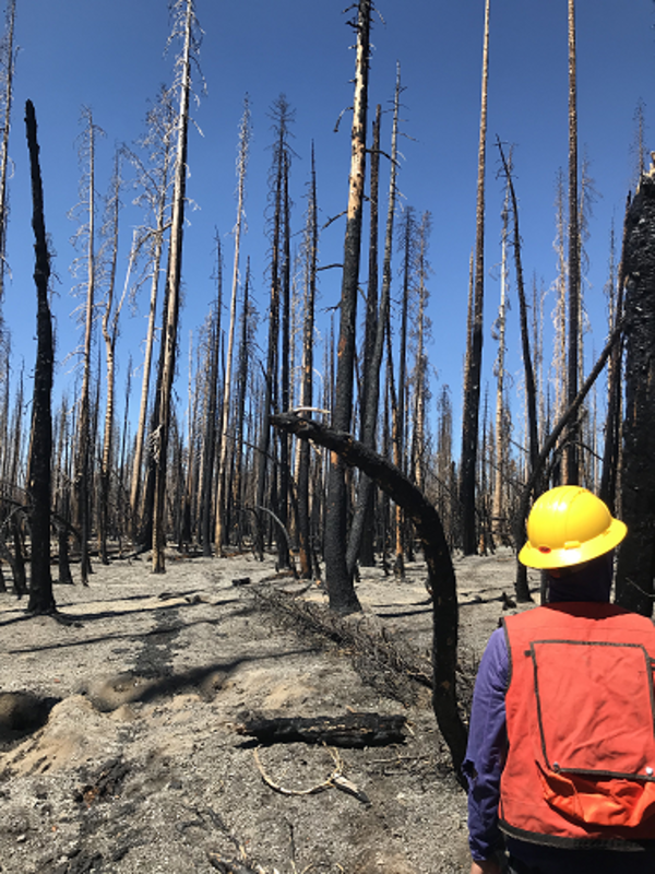
Dixie Fire, Lassen Volcanic National Park, California (2021)
USGS crew measuring forest conditions following the Dixie Fire in 2021. Lassen Volcanic National Park. California.
USGS crew measuring forest conditions following the Dixie Fire in 2021. Lassen Volcanic National Park. California.

Historic Cans
Historic cans from a refuse pile that were scorched by the combustion of nearby fuels during the Caldor Fire, California. Copyright: photo taken by Greg Snitker, Center for Applied Fire and Ecosystem Science, New Mexico Consortium.
Historic cans from a refuse pile that were scorched by the combustion of nearby fuels during the Caldor Fire, California. Copyright: photo taken by Greg Snitker, Center for Applied Fire and Ecosystem Science, New Mexico Consortium.

USGS 21st Century Science - WILDLAND FIRE (portrait)
$71-$246 BILLION
Net annual economic impact of wildland fire across the U.S.1
650 MILLION
Acres of public lands that are managed for wildland fire.2
16.1 FATALITIES
Average annual fatalities from wildland fire.3
$71-$246 BILLION
Net annual economic impact of wildland fire across the U.S.1
650 MILLION
Acres of public lands that are managed for wildland fire.2
16.1 FATALITIES
Average annual fatalities from wildland fire.3

I Am A Fire Ecologist - Coloring Page
This is a high resolution image for the whiteboard series I Am A Fire Ecologist - Coloring Page
By
This is a high resolution image for the whiteboard series I Am A Fire Ecologist - Coloring Page
By

Rim Fire in Yosemite National Park.
Rim Fire in Yosemite National Park.

Debris flow after the 2003 Old Gran Prix fire
Damage from a major post-wildfire landslide that occurred on 25 December 2003 near Devore, San Bernardino County as a result of the Old/Grand Prix fires that ran through the San Bernardino Mountains.
Damage from a major post-wildfire landslide that occurred on 25 December 2003 near Devore, San Bernardino County as a result of the Old/Grand Prix fires that ran through the San Bernardino Mountains.

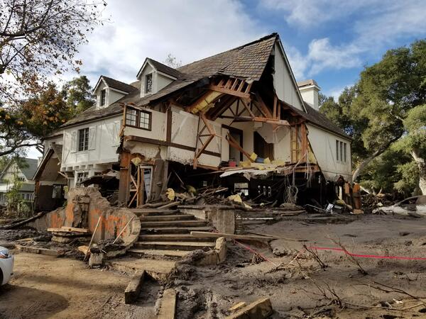
Home damaged by post-wildfire debris flow in Montecito, CA.
Damage from a major post-wildfire landslide that occurred on 9 January 2018 near Montecito, Santa Barbara County as a result of the 2017 Thomas Fire.
Damage from a major post-wildfire landslide that occurred on 9 January 2018 near Montecito, Santa Barbara County as a result of the 2017 Thomas Fire.

Thermal imaging for fire research
Use of thermal imaging helps researchers to understand the relationship of fuels and fire effects, Valles Caldera National Preserve, New Mexico, 2019.
Use of thermal imaging helps researchers to understand the relationship of fuels and fire effects, Valles Caldera National Preserve, New Mexico, 2019.

Hillside at Whiskeytown National Recreation Area 9 Months After Fire
Vegetation has begun to regrow in Whiskeytown National Recreation Area 9 months after summer 2018's Carr Fire near Redding, California, where USGS WERC researchers are studying fire impacts, post-fire vegetation recovery, and post-fire erosion and debris flows.
Vegetation has begun to regrow in Whiskeytown National Recreation Area 9 months after summer 2018's Carr Fire near Redding, California, where USGS WERC researchers are studying fire impacts, post-fire vegetation recovery, and post-fire erosion and debris flows.

Hill at Whiskeytown National Recreation Area 9 Months After Fire
Vegetation has begun to regrow in Whiskeytown National Recreation Area 9 months after summer 2018's Carr Fire near Redding, California, where USGS WERC researchers are studying fire impacts, post-fire vegetation recovery, and post-fire erosion and debris flows.
Vegetation has begun to regrow in Whiskeytown National Recreation Area 9 months after summer 2018's Carr Fire near Redding, California, where USGS WERC researchers are studying fire impacts, post-fire vegetation recovery, and post-fire erosion and debris flows.

Landscape at Whiskeytown National Recreation Area 9 Months After Fire
Vegetation has begun to regrow in Whiskeytown National Recreation Area 9 months after summer 2018's Carr Fire near Redding, California, where USGS WERC researchers are studying fire impacts, post-fire vegetation recovery, and post-fire erosion and debris flows.
Vegetation has begun to regrow in Whiskeytown National Recreation Area 9 months after summer 2018's Carr Fire near Redding, California, where USGS WERC researchers are studying fire impacts, post-fire vegetation recovery, and post-fire erosion and debris flows.

Hillside at Whiskeytown National Recreation Area 2 Months After Fire
A landscape at Whiskeytown National Recreation Area 2 months after summer 2018's Carr Fire near Redding, California, where USGS WERC researchers are studying fire impacts, post-fire vegetation recovery, and post-fire erosion and debris flows.
A landscape at Whiskeytown National Recreation Area 2 months after summer 2018's Carr Fire near Redding, California, where USGS WERC researchers are studying fire impacts, post-fire vegetation recovery, and post-fire erosion and debris flows.

Hill at Whiskeytown National Recreation Area 2 Months After Fire
A landscape at Whiskeytown National Recreation Area 2 months after summer 2018's Carr Fire near Redding, California, where USGS WERC researchers are studying fire impacts, post-fire vegetation recovery, and post-fire erosion and debris flows.
A landscape at Whiskeytown National Recreation Area 2 months after summer 2018's Carr Fire near Redding, California, where USGS WERC researchers are studying fire impacts, post-fire vegetation recovery, and post-fire erosion and debris flows.

Landscape at Whiskeytown National Recreation Area 2 Months After Fire
A landscape at Whiskeytown National Recreation Area 2 months after summer 2018's Carr Fire near Redding, California, where USGS WERC researchers are studying fire impacts, post-fire vegetation recovery, and post-fire erosion and debris flows.
A landscape at Whiskeytown National Recreation Area 2 months after summer 2018's Carr Fire near Redding, California, where USGS WERC researchers are studying fire impacts, post-fire vegetation recovery, and post-fire erosion and debris flows.

Hillside at Whiskeytown National Recreation Area 2 Months After Fire
A landscape at Whiskeytown National Recreation Area 2 months after summer 2018's Carr Fire near Redding, California, where USGS WERC researchers are studying fire impacts, post-fire vegetation recovery, and post-fire erosion and debris flows.
A landscape at Whiskeytown National Recreation Area 2 months after summer 2018's Carr Fire near Redding, California, where USGS WERC researchers are studying fire impacts, post-fire vegetation recovery, and post-fire erosion and debris flows.

Collecting soil and charcoal sample after a wildfire
Brett Tipple (University of California, Santa Cruz) collects a sample of charcoal and soil adjacent to a gully forming on a hillslope above Sonoma Creek, which was burned by the Nuns wildfire in October 2017.
Brett Tipple (University of California, Santa Cruz) collects a sample of charcoal and soil adjacent to a gully forming on a hillslope above Sonoma Creek, which was burned by the Nuns wildfire in October 2017.
Montecito home damaged by post-wildfire debrisflow.
Damage from a major post-wildfire landslide that occurred on 9 January 2018 near Montecito, Santa Barbara County as a result of the 2017 Thomas Fire.
Damage from a major post-wildfire landslide that occurred on 9 January 2018 near Montecito, Santa Barbara County as a result of the 2017 Thomas Fire.

Experimental herbicide treatment plot in Idaho
The Wildcat experimental treatment site in southwest Idaho at the base of the Owyhee Mountains. The brown square was treated with pre-emergent herbicide and is free of cheatgrass, a few native perennial bunchgrasses were able to establish. This image was taken the first Spring after treatment.
The Wildcat experimental treatment site in southwest Idaho at the base of the Owyhee Mountains. The brown square was treated with pre-emergent herbicide and is free of cheatgrass, a few native perennial bunchgrasses were able to establish. This image was taken the first Spring after treatment.