
Pacific salmon make stunning migrations, swimming hundreds of miles from the ocean up inland rivers. After using all of their energy to make this incredible journey and spawn, the salmon start to decay.
Images
Explore photos, graphics, and illustrations related to projects from across the CASC Network. And be sure to check out our Climate Illustrations page, featuring free-to-download illustrations that help describe tricky climate concepts and explain how climate change affects the world around us.
Filter Total Items: 272
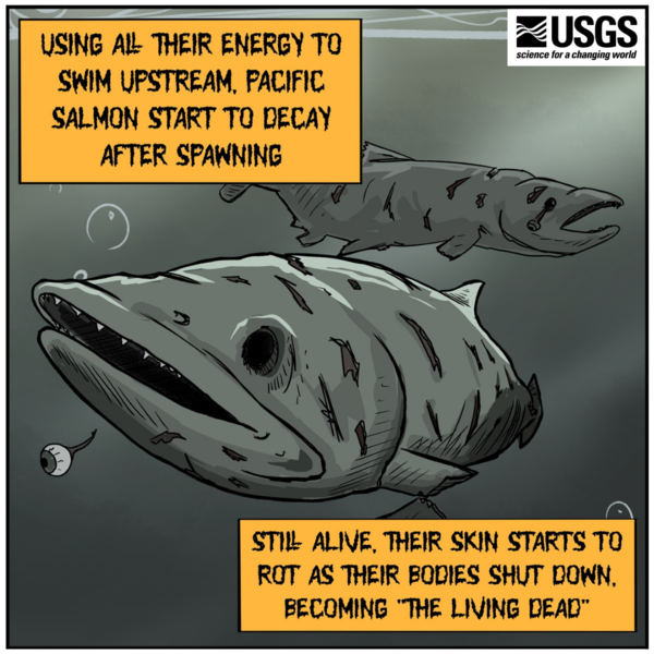
Zombie Salmon
Pacific salmon make stunning migrations, swimming hundreds of miles from the ocean up inland rivers. After using all of their energy to make this incredible journey and spawn, the salmon start to decay.
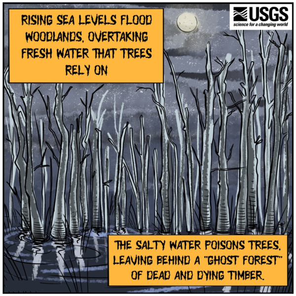
Ghost Forest
Rising sea levels inundate coastal forests across the Northeast and Southeast coasts, drowning tree roots in salty water. The seawater kills sensitive trees, leaving behind a "ghost forest" of dead and dying timber.
Created by ORISE Fellow Ben Slyngstad.
Rising sea levels inundate coastal forests across the Northeast and Southeast coasts, drowning tree roots in salty water. The seawater kills sensitive trees, leaving behind a "ghost forest" of dead and dying timber.
Created by ORISE Fellow Ben Slyngstad.


5 Ways Climate Affects Reptiles
Five ways climate change affects reptiles.
Graphic created by VSFS intern, Louise Johansson.
Five ways climate change affects reptiles.
Graphic created by VSFS intern, Louise Johansson.

Low Streamflow in the Byram River in Pemberwick, Connecticut
Hydrologic technicians took a low flow measurement of the Byram River at Pemberwick, Connecticut (streamgage 01212500), when water levels ran low during the 2022 drought.
Hydrologic technicians took a low flow measurement of the Byram River at Pemberwick, Connecticut (streamgage 01212500), when water levels ran low during the 2022 drought.

Coral reefs at Ofu, American Samoa
Coral reefs at Ofu, American Samoa, where USGS researchers are studying coral resilience to rising sea-surface temperatures, as well as the influence that submarine groundwater discharge may have on coral reef health.
Coral reefs at Ofu, American Samoa, where USGS researchers are studying coral resilience to rising sea-surface temperatures, as well as the influence that submarine groundwater discharge may have on coral reef health.
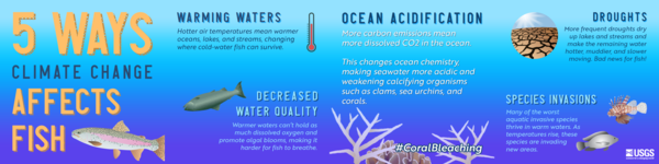
5 Ways Climate Change Affects Fish
Five ways climate change affects fish.
Infographic created by VSFS intern, Louise Johansson. Icons from Integration and Application Network | University of Maryland Center for Environmental Science (umces.edu)
Five ways climate change affects fish.
Infographic created by VSFS intern, Louise Johansson. Icons from Integration and Application Network | University of Maryland Center for Environmental Science (umces.edu)

Aunt Betty Pond Inlet, Acadia National Park
Aunt Betty Pond Inlet, Acadia National Park, Maine. Photo taken in the mid of summer.
Aunt Betty Pond Inlet, Acadia National Park, Maine. Photo taken in the mid of summer.

Raft containing sampling equipment on the shore of a recreational lake
An orange inflatable raft containing water sampling equipment sits on the shore of a recreational lake at Rapp Park and Recreation Area, Iowa.
An orange inflatable raft containing water sampling equipment sits on the shore of a recreational lake at Rapp Park and Recreation Area, Iowa.

Mountain goat in Glacier National park
Mountain goat standing next to a mostly frozen, high-elevation lake in Glacier National Park, Montana.
Mountain goat standing next to a mostly frozen, high-elevation lake in Glacier National Park, Montana.

Coastal flooding in southern New England during a storm event
Street flooding at high tide during a storm event on January 17, 2022, at Crescent Beach in Niantic, Connecticut.
Street flooding at high tide during a storm event on January 17, 2022, at Crescent Beach in Niantic, Connecticut.
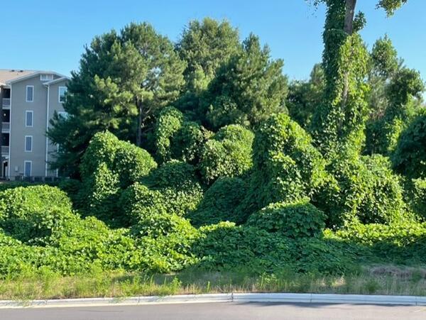
Kudzu is a voracious invasive species in the Southeast
Kudzu (genus Pueraria) is an invasive vine introduced to the United States from southeast Asia.
Kudzu (genus Pueraria) is an invasive vine introduced to the United States from southeast Asia.

Ruby Lake National Wildlife Reserve
Ruby Lake National Wildlife Refuge lies at the southern end of Ruby Valley in northeast Nevada. For more information visit the Ruby Lake NWR website.
By
Ecosystems Mission Area, Water Resources Mission Area, Land Management Research Program, Water Availability and Use Science Program, Forest and Rangeland Ecosystem Science Center, Fort Collins Science Center, Nevada Water Science Center, Oregon Water Science Center, Utah Water Science Center, Western Ecological Research Center (WERC), Saline Lakes Ecosystems Integrated Water Availability Assessment

Lake Ontario at Sunset
Sunset on Lake Ontario aboard the USGS Great Lakes Science Center’s R/V Kaho. Photo credit: Thomas SanFilippo, USGS.
Sunset on Lake Ontario aboard the USGS Great Lakes Science Center’s R/V Kaho. Photo credit: Thomas SanFilippo, USGS.

Tule white-fronted geese take off from Summer Lake Wildlife Area
Five tule white-fronted geese take off from Summer Lake Wildlife Area, the primary stopover site for this species on its fall migration.
Five tule white-fronted geese take off from Summer Lake Wildlife Area, the primary stopover site for this species on its fall migration.

Scenic view of the Beaufort Sea, Alaska
A scenic view of the Beaufort Sea, Alaska. This study site will evaluate the nearshore marine feeding areas of breeding adult red-throated loons and assess the response of loon reproductive success and nutritional content of nearshore fish communities.
A scenic view of the Beaufort Sea, Alaska. This study site will evaluate the nearshore marine feeding areas of breeding adult red-throated loons and assess the response of loon reproductive success and nutritional content of nearshore fish communities.
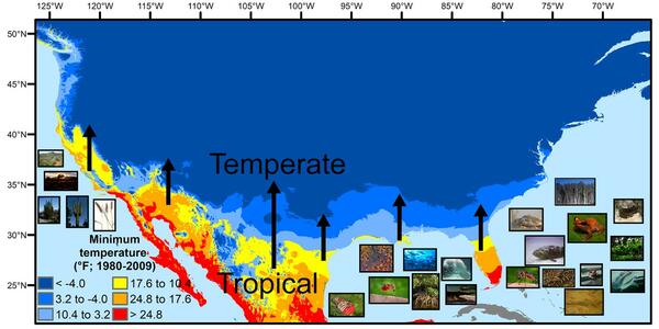
U.S. regions in the tropical-to-temperate transition
A map showing North America's tropical-to-temperate transition zone. Red, orange, and yellow depict the more tropical zones, and blues depict the more temperate zones, based on to the coldest recorded temperature for each area between 1980 and 2009.
A map showing North America's tropical-to-temperate transition zone. Red, orange, and yellow depict the more tropical zones, and blues depict the more temperate zones, based on to the coldest recorded temperature for each area between 1980 and 2009.
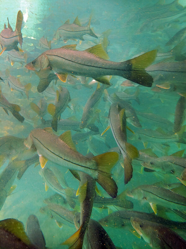
Subtropical snook gather at a warm Florida springhead in winter
Winter temperature extremes control the distributions of subtropical fishes. Common snook (Centropomus undecimalis), aggregate at a spring in northern Florida during winter. Snook are warm saltwater game fish, common in Florida, that have been moving further northward as extreme cold spells become less frequent and less intense.
Winter temperature extremes control the distributions of subtropical fishes. Common snook (Centropomus undecimalis), aggregate at a spring in northern Florida during winter. Snook are warm saltwater game fish, common in Florida, that have been moving further northward as extreme cold spells become less frequent and less intense.

Los Angeles River at USGS Streamgage 11092450 near Sepulveda Dam
A concrete-lined stretch of the Los Angeles River that runs near Sepulveda Dam. USGS streamgage 11092450 can be seen in the lower left along the river wall. Restoration is planned for this stretch of the river that runs through the San Fernando Valley.
A concrete-lined stretch of the Los Angeles River that runs near Sepulveda Dam. USGS streamgage 11092450 can be seen in the lower left along the river wall. Restoration is planned for this stretch of the river that runs through the San Fernando Valley.


JohnBradford_profile_photo.jpg
Profile photo of John Bradford, U.S. Geological Survey Southwest Biological Science Center
Profile photo of John Bradford, U.S. Geological Survey Southwest Biological Science Center