
Remote sensing, including Landsat satellite imagery, plays an important role in developing crop production estimates. In particular, the use of satellite imagery plays an important role in enhancing the accuracy and reliability of global crop production estimates (Vogel and Bange, 1999). Domestically, satellite imagery provides supplemental data to annual ground-based agricultural surveys. In addition to supplementing annual estimates, the ability of satellite imagery to provide near real-time production estimates of major crops is increasing, with significant strides occurring within the last decade. The task of estimating crop production is the responsibility of the National Agricultural Statistics Service (NASS) for domestic (U.S.) production and the Foreign Agricultural Service (FAS) for all global production (excluding the U.S.).
Remote sensing, including Landsat satellite imagery, plays an important role in developing crop production estimates. In particular, the use of satellite imagery plays an important role in enhancing the accuracy and reliability of global crop production estimates (Vogel and Bange, 1999). Domestically, satellite imagery provides supplemental data to annual ground-based agricultural surveys. In addition to supplementing annual estimates, the ability of satellite imagery to provide near real-time production estimates of major crops is increasing, with significant strides occurring within the last decade. The task of estimating crop production is the responsibility of the National Agricultural Statistics Service (NASS) for domestic (U.S.) production and the Foreign Agricultural Service (FAS) for all global production (excluding the U.S.).
Developing crop production estimates requires accurate assessment of two primary inputs: crop acreage and yield. Crop acreage is a measure of the land area in production while yield is an estimation of the productivity of that area. Currently, both the NASS and FAS rely on Landsat and DMC satellite imagery as primary sources for developing crop acreage estimates. Using a combination of red, near-infrared and shortwave infrared (only on Landsat) bands, acreage is derived using classification algorithms that can differentiate between specific crops. With two Landsat satellites currently in operation (7 and 8), a new moderate resolution (30-meter) scene can be acquired as often as every eight days. This interval represents ideal conditions as, realistically, most locations have an effective acquisition rate of a few cloud-free scenes per growing season.
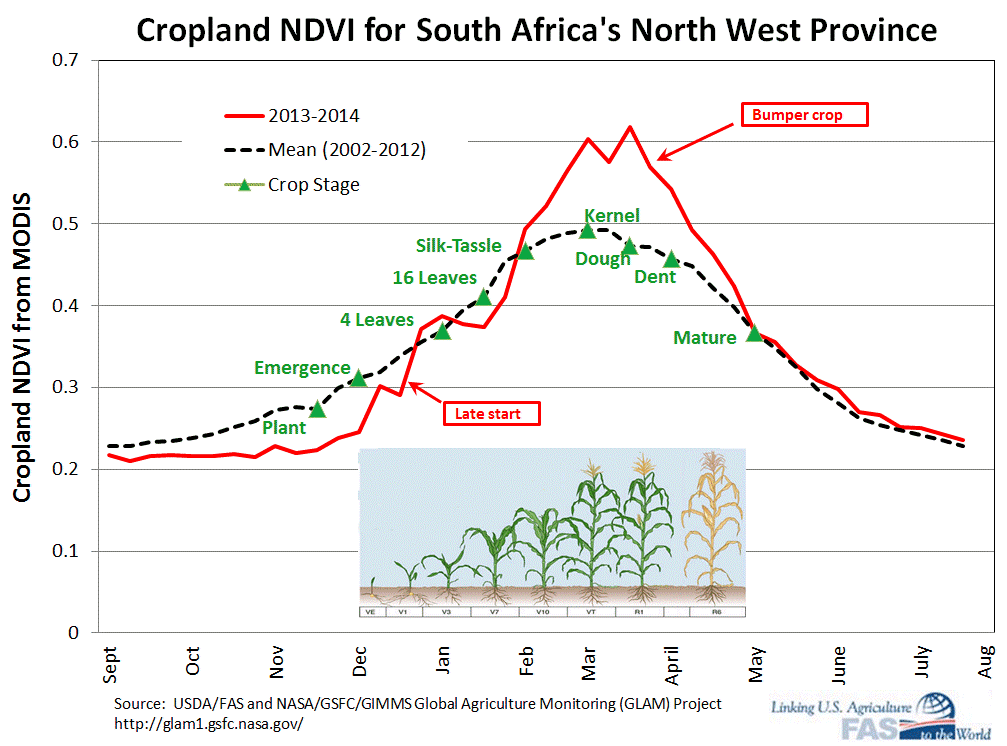
Yield estimates, when based on satellite imagery, rely primarily on vegetation indices, such as the Normalized Differential Vegetation Index (NDVI) to monitor crop phenology (Prasad and others, 2006). Broadly speaking, crop phenology can be divided into emergence, vegetative growth, flowering, fruit/seed development, and maturity. Crop coefficients, which are unique for each crop and based on the relationship between historic crop phenology and yield data, are then applied to estimate potential yield for the current crop. Figure 1 illustrates how current season cropland NDVI can be compared to a historical average to monitor crop condition.
NDVI for both NASS and FAS is primarily derived from imagery collected by the MODIS sensors onboard the Aqua and Terra satellites. At 250 meters, MODIS has significantly lower spatial resolution than Landsat. However, the higher revisit frequency of 1 to 3 days provided by the Aqua and Terra satellites is preferable to a higher resolution from Landsat, as crop phenology is dynamic throughout the growing season. MODIS imagery can also be used to derive crop acreage estimates: however, finer spatial resolution (such as Landsat 30-meter) significantly improves both the appearance and accuracy of crop classification (Johnson and Mueller, 2010). Currently, Landsat acreage estimates are used as an input mask to help increase the accuracy of MODIS NDVI. While this is generally a viable workaround, yield estimates cannot be made to the field level, which would require Landsat resolution imagery collected at a high enough frequency to provide global NDVI monitoring.
Benefits and Challenges of Using Landsat Imagery
For both the USDA, the benefit of using Landsat for crop monitoring is that the imagery provides an objective and unbiased assessment of farm-level crop production. The known stability of spectral and spatial resolution across Landsat satellites as well as the high level of image-data orthorectification and radiometric correction have helped establish Landsat as a gold standard among earth observation satellites. The thirty meter image-pixel resolution of the multi-spectral data collected by Landsat since 1982 has become a standard for land cover classification, enabling a high level of classification accuracy while balancing the processing realities of classifying imagery at a global scale (Johnson and Mueller, 2010). In practical terms, the availability of consistently collected (across multiple satellites/years), accurately corrected, and as of 2008, freely available, Landsat data is an important benefit for agencies such as the FAS, which remain primarily operational in nature with limited time and budget for purchasing satellite imagery from commercial sources (Curt Reynolds, USDA FAS, written commun. and oral commun., 2014).
The recent launch of Landsat 8 in 2013 has helped ensure the continuity of the Landsat mission. However, between 2003 and 2013, the primary challenge facing agencies like the USDA was uncertainty in the long-term outlook of the Landsat program and the pending data gap due to an aging Landsat 5 and SLC-off issue with Landsat 7 (Johnson and Mueller, 2010). Although Landsat 8 became fully operational in 2013, a number of challenges related to agricultural monitoring remain. The primary challenge is low global repeat frequency, which continues to provide a data gap for global agricultural monitoring. Occlusion of the land surface by clouds, such as over Brazil’s soybean region bordering the Amazon forest or for the Ethiopian Highlands, remains the main challenge, where generally only one cloud-free image is acquired per year. Ethiopia remains one of the largest U.S. food aid recipients and therefore of high interest for crop production monitoring, while Brazil has become one of the largest soybean producers in the world. While the concurrence of agricultural production with high rainfall means occlusion by clouds, prioritization of agricultural monitoring needs within the Landsat 8 Long Term Acquisition Plan could potentially increase the number of usable Landsat images obtained within major agricultural regions worldwide (Curt Reynolds, USDA FAS, written commun. and oral commun., 2014).
References
Johnson, D., and Mueller, R., 2010, The 2009 Cropland Data Layer: Photogrammetric Engineering & Remote Sensing, v. 76, no. 11, p. 1201.
Prasad, A. Chai, L., Singh, R., and Kafatos, M., 2006, Crop yield estimation model for Iowa using remote sensing and surface parameters: International Journal of Applied Earth Observation and Geoinformation, v. 8, no. 1, p. 26-33. doi:10.1016/j.jag.2005.06.002.

Case Studies of Landsat Imagery Use
Remote sensing, including Landsat satellite imagery, plays an important role in developing crop production estimates. In particular, the use of satellite imagery plays an important role in enhancing the accuracy and reliability of global crop production estimates (Vogel and Bange, 1999). Domestically, satellite imagery provides supplemental data to annual ground-based agricultural surveys. In addition to supplementing annual estimates, the ability of satellite imagery to provide near real-time production estimates of major crops is increasing, with significant strides occurring within the last decade. The task of estimating crop production is the responsibility of the National Agricultural Statistics Service (NASS) for domestic (U.S.) production and the Foreign Agricultural Service (FAS) for all global production (excluding the U.S.).
Remote sensing, including Landsat satellite imagery, plays an important role in developing crop production estimates. In particular, the use of satellite imagery plays an important role in enhancing the accuracy and reliability of global crop production estimates (Vogel and Bange, 1999). Domestically, satellite imagery provides supplemental data to annual ground-based agricultural surveys. In addition to supplementing annual estimates, the ability of satellite imagery to provide near real-time production estimates of major crops is increasing, with significant strides occurring within the last decade. The task of estimating crop production is the responsibility of the National Agricultural Statistics Service (NASS) for domestic (U.S.) production and the Foreign Agricultural Service (FAS) for all global production (excluding the U.S.).
Developing crop production estimates requires accurate assessment of two primary inputs: crop acreage and yield. Crop acreage is a measure of the land area in production while yield is an estimation of the productivity of that area. Currently, both the NASS and FAS rely on Landsat and DMC satellite imagery as primary sources for developing crop acreage estimates. Using a combination of red, near-infrared and shortwave infrared (only on Landsat) bands, acreage is derived using classification algorithms that can differentiate between specific crops. With two Landsat satellites currently in operation (7 and 8), a new moderate resolution (30-meter) scene can be acquired as often as every eight days. This interval represents ideal conditions as, realistically, most locations have an effective acquisition rate of a few cloud-free scenes per growing season.
Yield estimates, when based on satellite imagery, rely primarily on vegetation indices, such as the Normalized Differential Vegetation Index (NDVI) to monitor crop phenology (Prasad and others, 2006). Broadly speaking, crop phenology can be divided into emergence, vegetative growth, flowering, fruit/seed development, and maturity. Crop coefficients, which are unique for each crop and based on the relationship between historic crop phenology and yield data, are then applied to estimate potential yield for the current crop. Figure 1 illustrates how current season cropland NDVI can be compared to a historical average to monitor crop condition.
NDVI for both NASS and FAS is primarily derived from imagery collected by the MODIS sensors onboard the Aqua and Terra satellites. At 250 meters, MODIS has significantly lower spatial resolution than Landsat. However, the higher revisit frequency of 1 to 3 days provided by the Aqua and Terra satellites is preferable to a higher resolution from Landsat, as crop phenology is dynamic throughout the growing season. MODIS imagery can also be used to derive crop acreage estimates: however, finer spatial resolution (such as Landsat 30-meter) significantly improves both the appearance and accuracy of crop classification (Johnson and Mueller, 2010). Currently, Landsat acreage estimates are used as an input mask to help increase the accuracy of MODIS NDVI. While this is generally a viable workaround, yield estimates cannot be made to the field level, which would require Landsat resolution imagery collected at a high enough frequency to provide global NDVI monitoring.
Benefits and Challenges of Using Landsat Imagery
For both the USDA, the benefit of using Landsat for crop monitoring is that the imagery provides an objective and unbiased assessment of farm-level crop production. The known stability of spectral and spatial resolution across Landsat satellites as well as the high level of image-data orthorectification and radiometric correction have helped establish Landsat as a gold standard among earth observation satellites. The thirty meter image-pixel resolution of the multi-spectral data collected by Landsat since 1982 has become a standard for land cover classification, enabling a high level of classification accuracy while balancing the processing realities of classifying imagery at a global scale (Johnson and Mueller, 2010). In practical terms, the availability of consistently collected (across multiple satellites/years), accurately corrected, and as of 2008, freely available, Landsat data is an important benefit for agencies such as the FAS, which remain primarily operational in nature with limited time and budget for purchasing satellite imagery from commercial sources (Curt Reynolds, USDA FAS, written commun. and oral commun., 2014).
The recent launch of Landsat 8 in 2013 has helped ensure the continuity of the Landsat mission. However, between 2003 and 2013, the primary challenge facing agencies like the USDA was uncertainty in the long-term outlook of the Landsat program and the pending data gap due to an aging Landsat 5 and SLC-off issue with Landsat 7 (Johnson and Mueller, 2010). Although Landsat 8 became fully operational in 2013, a number of challenges related to agricultural monitoring remain. The primary challenge is low global repeat frequency, which continues to provide a data gap for global agricultural monitoring. Occlusion of the land surface by clouds, such as over Brazil’s soybean region bordering the Amazon forest or for the Ethiopian Highlands, remains the main challenge, where generally only one cloud-free image is acquired per year. Ethiopia remains one of the largest U.S. food aid recipients and therefore of high interest for crop production monitoring, while Brazil has become one of the largest soybean producers in the world. While the concurrence of agricultural production with high rainfall means occlusion by clouds, prioritization of agricultural monitoring needs within the Landsat 8 Long Term Acquisition Plan could potentially increase the number of usable Landsat images obtained within major agricultural regions worldwide (Curt Reynolds, USDA FAS, written commun. and oral commun., 2014).
References
Johnson, D., and Mueller, R., 2010, The 2009 Cropland Data Layer: Photogrammetric Engineering & Remote Sensing, v. 76, no. 11, p. 1201.
Prasad, A. Chai, L., Singh, R., and Kafatos, M., 2006, Crop yield estimation model for Iowa using remote sensing and surface parameters: International Journal of Applied Earth Observation and Geoinformation, v. 8, no. 1, p. 26-33. doi:10.1016/j.jag.2005.06.002.