
USGS Data Collection: Real-Time Rain Gages for Post Conchas-Fire Flood-Early Warning System
The Las Conchas fire started on June 26, 2011, near the small community of Las Conchas in the Jemez Mountains of north-central New Mexico. When the fire was contained on August 3, 2011, it had burned 156,593 acres of mixed conifer, pinyon/juniper, and ponderosa forest. At the time, it was the largest wildfire in New Mexico history. Peak burn severity was extreme; over 60,000 acres of the total burned in the first 2 days.

Approach
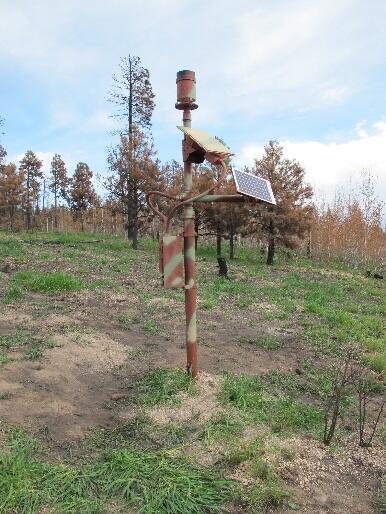
- Four rain gages are installed in the upper watershed of the burn scar
- Rain gages act as the primary sensors, or data inputs, into a flood EWS operated and maintained by the USACE or other provider
- USGS downloads data from the alarm system provider and enters it into the USGS NWIS database; data is checked, reviewed, and approved on a regular basis and in accordance with USGS standards

Objectives
In response to this fire, numerous governmental and non-governmental agencies sought to create an early-warning system (EWS) to help protect downstream communities and the general public from the post-burn flooding. As part of the interagency collaboration, the USGS installed rain gages to act as the primary sensors necessary to activate the alarms for this system.
The Las Conchas fire started on June 26, 2011, near the small community of Las Conchas in the Jemez Mountains of north-central New Mexico. When the fire was contained on August 3, 2011, it had burned 156,593 acres of mixed conifer, pinyon/juniper, and ponderosa forest. At the time, it was the largest wildfire in New Mexico history. Peak burn severity was extreme; over 60,000 acres of the total burned in the first 2 days.
Approach
- Four rain gages are installed in the upper watershed of the burn scar
- Rain gages act as the primary sensors, or data inputs, into a flood EWS operated and maintained by the USACE or other provider
- USGS downloads data from the alarm system provider and enters it into the USGS NWIS database; data is checked, reviewed, and approved on a regular basis and in accordance with USGS standards
Objectives
In response to this fire, numerous governmental and non-governmental agencies sought to create an early-warning system (EWS) to help protect downstream communities and the general public from the post-burn flooding. As part of the interagency collaboration, the USGS installed rain gages to act as the primary sensors necessary to activate the alarms for this system.