Earthquake Hazards Program
A
Acceleration/peak acceleration
When you push on the gas pedal in the car or put on the brakes, the car goes faster or slower. When it is changing from one speed to another, it is accelerating (faster) or decelerating (slower). This change from one speed, or velocity, to another is called acceleration. Technically, then, acceleration is how much the velocity changes in a unit time.
During an earthquake when the ground is shaking, it also experiences acceleration. The peak acceleration is the largest increase in velocity recorded by a particular station during an earthquake.
![Three graphs with the x-axis labelled "Time (s)": the first labelled "Acceleration (cm/s^2)," the second labelled "Velocity (cm/s)," and the third labelled "Displacement (cm)."](https://d9-wret.s3.us-west-2.amazonaws.com/assets/palladium/production/s3fs-public/styles/list_item/public/media/images/acceleration%20velocity%20displacement.gif?itok=SmrrvJHb)
Accelerogram
Accelerogram
The recording of the acceleration of the ground during an earthquake.
![Photo of a black, square device with rounded corners on a green background](https://d9-wret.s3.us-west-2.amazonaws.com/assets/palladium/production/s3fs-public/styles/list_item/public/media/images/accelerograph.jpg?itok=scpRiFr_)
Accelerograph
Accelerograph
An instrument that records the acceleration of the ground during an earthquake, also commonly called an accelerometer.
![cartoon sketch of accretionary wedge](https://d9-wret.s3.us-west-2.amazonaws.com/assets/palladium/production/s3fs-public/styles/list_item/public/thumbnails/image/eq-ed-accretionary-wedge.gif?itok=jpzi5EyX)
Accretionary wedge
Accretionary wedge
Sediments, the top layer of material on a tectonic plate, that accumulate and deform where oceanic and continental plates collide. These sediments are scraped off the top of the downgoing oceanic crustal plate and are appended to the edge of the continental plate.
![Photo showing a crack in the brown ground with a mountain in the background.](https://d9-wret.s3.us-west-2.amazonaws.com/assets/palladium/production/s3fs-public/styles/list_item/public/media/images/active_fault.jpg?itok=tGTDjely)
Active fault
Active fault
A fault that is likely to have another earthquake sometime in the future. Faults are commonly considered to be active if they have moved one or more times in the last 10,000 years.
![The Landers fault (red lines at left) and the Hector Mine fault and its aftershocks (red lines and circles at right).](https://d9-wret.s3.us-west-2.amazonaws.com/assets/palladium/production/s3fs-public/styles/list_item/public/media/images/aftershocks1.gif?itok=qDa-gd92)
Aftershocks
Aftershocks
Earthquakes that follow the largest shock of an earthquake sequence. They are smaller than the mainshock and within 1-2 rupture lengths distance from the mainshock. Aftershocks can continue over a period of weeks, months, or years. In general, the larger the mainshock, the larger and more numerous the aftershocks, and the longer they will continue.
![Aerial photo of Salt River, Arizona with a meandering river surrounded by brown alluvium](https://d9-wret.s3.us-west-2.amazonaws.com/assets/palladium/production/s3fs-public/styles/list_item/public/media/images/alluvium-salt-river-arizona.jpg?itok=DAVOgZ4g)
Alluvium
Alluvium
Loose gravel, sand, silt, or clay deposited by current or past streams.
![Map of the Los Angeles region in California with a color gradient of purple to yellow showing amplification values.](https://d9-wret.s3.us-west-2.amazonaws.com/assets/palladium/production/s3fs-public/styles/list_item/public/media/images/amplification.jpg?itok=Fw700tcJ)
Amplification
Amplification
Shaking levels at a site may be increased, or amplified, by focusing of seismic energy caused by the geometry of the sediment velocity structure, such as basin subsurface topography, or by surface topography.
![Graph with 3 seismic waves: The blue wave has the highest peaks and is labelled "high amplitude," the green has medium peaks and is labelled "medium amplitude," and the red has the smallest peaks and is labelled "low amplitude."](https://d9-wret.s3.us-west-2.amazonaws.com/assets/palladium/production/s3fs-public/styles/list_item/public/media/images/amplitude1.gif?itok=qXE5TX4I)
Amplitude
Amplitude
The size of the wiggles on an earthquake recording.
![A diagram on a white background depicting the tectonic components of a volcanic arc, including the back arc spreading center, back arc convection cell, zone of fractional melting, outer arc trough, outer arc ridge, subducting oceanic lithosphere, and asthenosphere.](https://d9-wret.s3.us-west-2.amazonaws.com/assets/palladium/production/s3fs-public/styles/list_item/public/media/images/arc.gif?itok=Q7WAVMb1)
Arc
Arc
A chain of volcanoes (volcanic arc) that sometimes forms on the land when an oceanic plate collides with a continental plate and then slides down underneath it (subduction)
![Evidence of Fault Creep Along the Hayward Fault](https://d9-wret.s3.us-west-2.amazonaws.com/assets/palladium/production/s3fs-public/styles/list_item/public/thumbnails/image/creep_GardeniaEE_crax.jpg?itok=GIetSthP)
Aseismic
Aseismic
A fault on which no earthquakes have been observed.
![A yellow parallelogram labelled "Fault Surface" with a pink blob on the left side labelled "Asperity"](https://d9-wret.s3.us-west-2.amazonaws.com/assets/palladium/production/s3fs-public/styles/list_item/public/media/images/ASPERITY.gif?itok=HBajDMpt)
Asperity
Asperity
An area on a fault that is stuck. The earthquake rupture usually begins at an asperity.
![A diagram on a blue background showing a slice of the Earth's lithosphere, including continental crust (green), oceanic crust (maroon), asthenosphere (pink), and the upper mantle (yellow).](https://d9-wret.s3.us-west-2.amazonaws.com/assets/palladium/production/s3fs-public/styles/list_item/public/media/images/asthenosphere_0.jpg?itok=K_lU_W8j)
Asthenosphere
Asthenosphere
The ductile part of the earth just below the lithosphere, including the upper mantle. The asthenosphere is about 180 km thick.
![Photo of a reflection in water with ripples](https://d9-wret.s3.us-west-2.amazonaws.com/assets/palladium/production/s3fs-public/styles/list_item/public/media/images/attenuation%20ripples.jpg?itok=tpO8H_4F)
Attenuation
Attenuation
When you throw a pebble in a pond, it makes waves on the surface that move out from the place where the pebble entered the water. The waves are largest where they are formed and gradually get smaller as they move away. This decrease in size, or amplitude, of the waves is called attenuation. Seismic waves also become attenuated as they move away from the earthquake source.
B
![A diagram on a white background depicting the tectonic components of a volcanic arc, including the back arc spreading center, back arc convection cell, zone of fractional melting, outer arc trough, outer arc ridge, subducting oceanic lithosphere, and asthenosphere.](https://d9-wret.s3.us-west-2.amazonaws.com/assets/palladium/production/s3fs-public/styles/list_item/public/media/images/arc.gif?itok=Q7WAVMb1)
Backarc
Backarc
The region landward of the volcanic chain on the other side from the subduction zone.
![An illustration showing two stick figures doing basement excavations, one with a frown that excavated into the labelled hard, stable bedrock on the left and the other with a smile that excavated above the labelled bedrock surface. There is a bridge overlying water on the right hand side.](https://d9-wret.s3.us-west-2.amazonaws.com/assets/palladium/production/s3fs-public/styles/list_item/public/media/images/basement.gif?itok=XznOB2p4)
Basement
Basement
Harder and usually older igneous and metamorphic rocks that underlie the main sedimentary rock sequences (softer and usually younger) of a region and extend downward to the base of the crust.
![An illustration showing two stick figures doing basement excavations, one with a frown that excavated into the labelled hard, stable bedrock on the left and the other with a smile that excavated above the labelled bedrock surface. There is a bridge overlying water on the right hand side.](https://d9-wret.s3.us-west-2.amazonaws.com/assets/palladium/production/s3fs-public/styles/list_item/public/media/images/basement.gif?itok=XznOB2p4)
Bedrock
Bedrock
Relatively hard, solid rock that commonly underlies softer rock, sediment, or soil; a subset of the basement.
![A diagram with a labelled Benioff Zone beside red x's labelled as "earthquake focus" under an interaction of an oceanic and continental lithosphere.](https://d9-wret.s3.us-west-2.amazonaws.com/assets/palladium/production/s3fs-public/styles/list_item/public/media/images/benioff_zone.gif?itok=DazlK8t-)
Benioff zone
Benioff zone
A dipping planar (flat) zone of earthquakes that is produced by the interaction of a downgoing oceanic crustal plate with a continental plate. These earthquakes can be produced by slip along the subduction thrust fault or by slip on faults within the downgoing plate as a result of bending and extension as the plate is pulled into the mantle. Also known as the Wadati-Benioff zone.
![A diagram of blind thrust fault with arrows on the left and right pointed inward to indicate movement and resulting in labelled ductile rock layers folding.](https://d9-wret.s3.us-west-2.amazonaws.com/assets/palladium/production/s3fs-public/styles/list_item/public/media/images/blindthrust.gif?itok=osCKk8bk)
Blind thrust fault
Blind thrust fault
A thrust fault that does not rupture all the way up to the surface so there is no evidence of it on the ground. It is "buried" under the uppermost layers of rock in the crust.
![wiggly red line across page from left to right](https://d9-wret.s3.us-west-2.amazonaws.com/assets/palladium/production/s3fs-public/styles/list_item/public/media/images/P%26S-waves.gif?h=9e80746d&itok=jnSOHLid)
Body wave
Body wave
A seismic wave that moves through the interior of the earth, as opposed to surface waves that travel near the earth's surface. P and S waves are body waves. Each type of wave shakes the ground in different ways.
![A sketch of the thinner crust and thicker mantle. The crust and top portion of the mantle are labelled "Lithosphere "strong'" and the bottom portion of the mantle (bottom) labelled "Asthenosphere "weak.'"](https://d9-wret.s3.us-west-2.amazonaws.com/assets/palladium/production/s3fs-public/styles/list_item/public/media/images/brittle_ductile.gif?itok=iewyXTi5)
Brittle-ductile boundary
The depth in the crust where the crust changes from being brittle (tending to break) above, to being ductile (tending to bend) below. Most earthquakes occur in the brittle portion of the crust above the brittle-ductile boundary.
C
![A diagram with 3 yellow squares with arrows pointing to indicate steps. The first yellow square has all white dots and is labelled "Time 1: pure parent isotope," the second/middle yellow square has half white dots and half green dots (labelled as the daughter isotopes) and is labelled "After 1 half life: 1/2 parent and 1/2 daughter isotope," and the third yellow square has a quarter white dots and three-quarters green dots and is labelled "After 2 half lives: 1/4 parent and 3/4 daughter isotopes."](https://d9-wret.s3.us-west-2.amazonaws.com/assets/palladium/production/s3fs-public/styles/list_item/public/media/images/CARBON14.gif?itok=AwsGvj4p)
Carbon 14 age
Carbon 14 age
An absolute age obtained for geologic materials containing bits or pieces of carbon using measurements of the proportion of radioactive carbon (14 C) to daughter carbon (12 C). These dates are independently calibrated with calendar dates. This is used to determine when past earthquakes occurred on a fault.
![A diagram showing three stress types on cubes: the first is labelled "tensional stress" with arrows pointed outwards, the second is labelled "compressional stress" with arrows pointed inwards, and the third is labelled "shear stress" with arrows pointed parallel to each other.](https://d9-wret.s3.us-west-2.amazonaws.com/assets/palladium/production/s3fs-public/styles/list_item/public/media/images/stress_types.gif?itok=V3BSY5b0)
Compressional stress
The stress that squeezes something. It is the stress component perpendicular to a given surface, such as a fault plane, that results from forces applied perpendicular to the surface or from remote forces transmitted through the surrounding rock.
![Diagram showing a cone cross-section of the Earth with lithosphere (green), mantle (brown), and the core divided into the metallic liquid core (gray) and the solid inner core (black).](https://d9-wret.s3.us-west-2.amazonaws.com/assets/palladium/production/s3fs-public/styles/list_item/public/media/images/CORE.gif?itok=8YT25Rn6)
Core
Core
The innermost part of the earth. The outer core extends from 2500 to 3500 miles below the earth's surface and is liquid metal. The inner core is the central 500 miles and is solid metal. (See also Earthquake ABC)
![Photograph showing cracks from a fault on a pavement road with a group of people standing by a rock outcrop in the background.](https://d9-wret.s3.us-west-2.amazonaws.com/assets/palladium/production/s3fs-public/styles/list_item/public/media/images/CREEP.jpg?itok=NikR7nPm)
Creep/fault creep
Creep/fault creep
Slow, more or less continuous movement occurring on faults due to ongoing tectonic deformation. Faults that are creeping do not tend to have large earthquakes.
![A cone diagram showing a slice of the Earth's crust with continental (gray) and oceanic crust (black).](https://d9-wret.s3.us-west-2.amazonaws.com/assets/palladium/production/s3fs-public/styles/list_item/public/media/images/CRUST.jpg?itok=8KXxoVak)
Crust
Crust
The outermost major layer of the earth, ranging from about 10 to 65 km in thickness worldwide. The uppermost 15-35 km of crust is brittle enough to produce earthquakes.
D
![Photo of a deformed rock with folds and cracks, with a rock hammer for scale and labelled "P Gore 1976".](https://d9-wret.s3.us-west-2.amazonaws.com/assets/palladium/production/s3fs-public/styles/list_item/public/media/images/deformation.jpg?itok=81lVrG3a)
Deformation
Deformation
A change in the original shape of a material. When we are talking about earthquakes, deformation is due to stress and strain.
![A diagram showing how dip is the angle of a fault from the horizontal surface.](https://d9-wret.s3.us-west-2.amazonaws.com/assets/palladium/production/s3fs-public/styles/list_item/public/media/images/DIP.gif?itok=XOJslamF)
Dip
Dip
The angle that a planar geologic surface (for example, a fault) is inclined from the horizontal.
![ShakeMap with a color gradient to display directivity after an earthquake.](https://d9-wret.s3.us-west-2.amazonaws.com/assets/palladium/production/s3fs-public/styles/list_item/public/media/images/directivity.jpg?itok=w77Q-KVL)
Directivity
Directivity
An effect of a fault rupturing whereby earthquake ground motion in the direction of rupture propagation is more severe than that in other directions from the earthquake source.
![Three graphs with the x-axis labelled "Time (s)": the first labelled "Acceleration (cm/s^2)," the second labelled "Velocity (cm/s)," and the third labelled "Displacement (cm)."](https://d9-wret.s3.us-west-2.amazonaws.com/assets/palladium/production/s3fs-public/styles/list_item/public/media/images/acceleration%20velocity%20displacement.gif?itok=SmrrvJHb)
Displacement
Displacement
The difference between the initial position of a reference point and any later position. The amount any point affected by an earthquake has moved from where it was before the earthquake.
E
![Image of graph with seismic waves (squiggles) on it](https://d9-wret.s3.us-west-2.amazonaws.com/assets/palladium/production/s3fs-public/styles/list_item/public/media/images/earthquake%20seismogram.gif?itok=GAjpGT-Z)
Earthquake
Earthquake
A term used to describe both sudden slip on a fault AND the ground shaking that occurs from the radiated seismic energy during the slipping event. The sudden slip can be caused by stress changes in the earth or volcanic/magmatic activity.
![Map of the United States with color gradient showing seismic hazard with the highest hazard being concentrated on the west coast in red.](https://d9-wret.s3.us-west-2.amazonaws.com/assets/palladium/production/s3fs-public/styles/list_item/public/media/images/earthquake%20seismic%20hazard%20map.gif?itok=x7mhMIbu)
Earthquake hazard
Earthquake hazard
Anything associated with an earthquake that may affect the normal activities of people. This includes surface faulting, ground shaking, landslide, liquefaction, tectonic deformation, tsunamis, and seiches.
![Map of the United States with color gradient showing seismic hazard with the highest hazard being concentrated on the west coast in red.](https://d9-wret.s3.us-west-2.amazonaws.com/assets/palladium/production/s3fs-public/styles/list_item/public/media/images/earthquake%20seismic%20hazard%20map.gif?itok=x7mhMIbu)
Earthquake risk
Earthquake risk
The probable building damage, and number of people that are expected to be hurt or killed if a likely earthquake on a particular fault occurs. Earthquake risk and earthquake hazard are occasionally incorrectly used interchangeably.
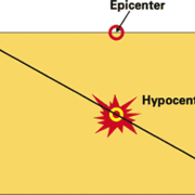
![A yellow rectangle with a diagonal line with a hypocenter explosion symbol on the line and an epicenter circle labelled on the top side of the rectangle directly above the hypocenter.](https://d9-wret.s3.us-west-2.amazonaws.com/assets/palladium/production/s3fs-public/styles/list_item/public/media/images/Epicenter%20Hypocenter.gif?itok=cUu0YtJk)
Epicenter
Epicenter
The point on the earth's surface vertically above the hypocenter (or focus), point in the crust where a seismic rupture begins.
F
![Three diagrams showing types of faults. Strike-slip is shown with the blocks of crust moving parallel to each other. The normal fault is shown with a fault at an angle and the overhanging block sliding downward. The thrust fault is shown with the same angle of the fault but the overhanging block is sliding upwards.](https://d9-wret.s3.us-west-2.amazonaws.com/assets/palladium/production/s3fs-public/styles/list_item/public/media/images/FAULT.gif?itok=Jrls3csY)
Fault
Fault
A fracture along which the blocks of crust on either side have moved relative to one another parallel to the fracture.
![Photo of a rock outcrop with cracks with a pen placed for scale](https://d9-wret.s3.us-west-2.amazonaws.com/assets/palladium/production/s3fs-public/styles/list_item/public/media/images/Fault-Gouge_0.jpg?itok=TnLdwUpE)
Fault gouge
Fault gouge
Crushed and ground-up rock produced by friction between the two sides when a fault moves.
![Fault block diagram showing the different aspects of a fault plane. The fault plane is the plane along which the blocks of crusts slide.. The "focus" on the fault line with circles showing earthquake reverberations. The epicenter is directly above the focus on the surface. The fault scarp is the area on the fault plane that is left open when the fault block slides downwards.](https://d9-wret.s3.us-west-2.amazonaws.com/assets/palladium/production/s3fs-public/styles/list_item/public/media/images/fault_plane_diagram.jpg?itok=kQtJIZ0n)
Fault plane
Fault plane
The planar (flat) surface along which there is slip during an earthquake.
![Photo of fault scarp with crushed rock surrounding and two people standing on top of scarp](https://d9-wret.s3.us-west-2.amazonaws.com/assets/palladium/production/s3fs-public/styles/list_item/public/media/images/FAULT-SCARP.jpg?itok=_lSKCe0U)
Fault scarp
Fault scarp
The feature on the surface of the earth that looks like a step caused by slip on the fault.
![Photograph of fault trace on ground with mountains in the background. Fault trace looks like a large crack on the surface](https://d9-wret.s3.us-west-2.amazonaws.com/assets/palladium/production/s3fs-public/styles/list_item/public/media/images/FAULT-TRACE.jpg?itok=K_78nm8s)
Fault trace
Fault trace
The intersection of a fault with the ground surface; also, the line commonly plotted on geologic maps to represent a fault.
![First motion diagram: a circle split into quadrants with hollow white circles in the upper left and lower right and solid black circles in the upper right and lower left. There is an arrow pointing down and another pointing right from the upper left quadrant, and an arrow pointing up and another pointing left from the lower right quadrant.](https://d9-wret.s3.us-west-2.amazonaws.com/assets/palladium/production/s3fs-public/styles/list_item/public/media/images/firstmotion.gif?itok=UHxyVBRs)
First motion
First motion
On a seismogram, the first motion is the direction of ground motion as the P wave arrives at the seismometer. Upward ground motion indicates an expansion in the source region; downward motion indicates a contraction.
![Diagram of dipping slab with different focal depth events shown at different depths.](https://d9-wret.s3.us-west-2.amazonaws.com/assets/palladium/production/s3fs-public/styles/list_item/public/media/images/focal%20depth.gif?itok=fKVZtH8R)
Focal depth
Focal depth
The depth of an earthquake hypocenter.
![5 diagrams of stereonets for reverse, normal, strike-slip, low-angle reverse, and oblique faults.](https://d9-wret.s3.us-west-2.amazonaws.com/assets/palladium/production/s3fs-public/styles/list_item/public/media/images/focal_mechanism.gif?itok=givYhum-)
Focal mechanism solution/fault plane solution
A way of showing the fault and the direction of slip on it from an earthquake, using circles with two intersecting curves that look like beach balls. Also called a focal-mechanism solution.
See also moment tensor
![A diagram on a white background depicting the tectonic components of a volcanic arc, including the back arc spreading center, back arc convection cell, zone of fractional melting, outer arc trough, outer arc ridge, subducting oceanic lithosphere, and asthenosphere.](https://d9-wret.s3.us-west-2.amazonaws.com/assets/palladium/production/s3fs-public/styles/list_item/public/media/images/arc.gif?itok=Q7WAVMb1)
Forearc
Forearc
The region between the subduction zone and the volcanic chain (volcanic arc).
![Seismic record with red, blue, and black waves. The largest seismic wave is labelled "Main shock," the second largest is labelled "Aftershock," and the third largest is labelled "foreshock.""](https://d9-wret.s3.us-west-2.amazonaws.com/assets/palladium/production/s3fs-public/styles/list_item/public/media/images/foreshock.gif?itok=uamwg2ZY)
Foreshocks
Foreshocks
Relatively smaller earthquakes that precede the largest earthquake in a series, which is termed the mainshock. Not all mainshocks have foreshocks.
![Graph of frequency with time as the x-axis and amplitude as the y-axis](https://d9-wret.s3.us-west-2.amazonaws.com/assets/palladium/production/s3fs-public/styles/list_item/public/media/images/frequency.gif?itok=G4aTqopU)
Frequency
Frequency
The number of times something happens in a certain period of time, such as the ground shaking up and down or back and forth during an earthquake.
G
![Drawing of Isaac Newton sitting on a hill under an apple tree](https://d9-wret.s3.us-west-2.amazonaws.com/assets/palladium/production/s3fs-public/styles/list_item/public/media/images/GRAVITY.jpg?itok=d6xPV_io)
G or g
G or g
The acceleration of gravity 9.8 (m/s2) or the strength of the gravitational field (N/kg) (which it turns out is equivalent).
When acceleration acts on a physical body, the body experiences the acceleration as a force. The force we are most experienced with is the force of gravity, which causes us to have weight.
The equation for the force of gravity is F = mg, at the surface of the earth, or F = GMm/r2 at a distance r from the center of the earth (where r is greater than the radius of the earth). G is the proportionality constant 6.67x10⁻¹¹ (N-m2/kg2) in Newton's law of gravity.
When there is an earthquake, the forces caused by the shaking can be measured as a percentage of gravity, or percent g.
For example: The shaking at a particular location is measured as an acceleration of 11 feet per second, or 11*12*2.54 cm/sec/sec = 335 cm/sec/sec. The acceleration due to gravity is 980 cm/sec/sec, so the measured shaking is 335/980, or 0.34 g. As a percentage, this is 34% g.
![Photo of a snowy area with an instrument placed on the ground. The instrument looks like a small pyramid on top of a tripod.](https://d9-wret.s3.us-west-2.amazonaws.com/assets/palladium/production/s3fs-public/styles/list_item/public/media/images/GEODESY.jpg?itok=x8etTNSE)
Geodesy/geodetic
Geodesy/geodetic
The science of determining the size and shape of the earth and the precise location of points on its surface. / The use of geodesy for measurements.
![Blurry table of the geologic time scale](https://d9-wret.s3.us-west-2.amazonaws.com/assets/palladium/production/s3fs-public/styles/list_item/public/media/images/geologic%20timescale.jpg?itok=L8BoYedL)
Geologic time scale
Geologic time scale
A chronological sequence of geologic events usually represented in the form of a chart showing names of various rock layers and indicating the estimated duration of each geologic unit.
![Photo of mountains in Zion Canyon with trees in the foreground](https://d9-wret.s3.us-west-2.amazonaws.com/assets/palladium/production/s3fs-public/styles/list_item/public/media/images/photo-of-zion-canyon-_geology_.jpg?itok=4zrYI5U3)
Geology
Geology
The study of the planet earth- the materials it is made of, the processes that act on those materials, the products formed, and the history of the planet and its life forms since its origin.
![Photo of mountains in the Grand Canyon](https://d9-wret.s3.us-west-2.amazonaws.com/assets/palladium/production/s3fs-public/styles/list_item/public/media/images/photo%20of%20grand%20canyon%20%28geomorphology%29.jpg?itok=W4DeSIqy)
Geomorphology
Geomorphology
The study of the character and origin of landforms, such as mountains, valleys, etc.
![Photo of GPS site with a white instrument on a white tripod and a solar panel](https://d9-wret.s3.us-west-2.amazonaws.com/assets/palladium/production/s3fs-public/styles/list_item/public/media/images/GPS%20site%20%28geophysics%29.jpg?itok=ZZu-2Kvy)
Geophysics
Geophysics
The branch of earth science which employs physical measurements and mathematical models to explore and analyze the structure and dynamics of the solid Earth and similar bodies and their fluid envelopes.
![Photo of a bridge over a valley with a semi-transparent textbox labelled "www.worldweb.com. Photo c Jim Forrest"](https://d9-wret.s3.us-west-2.amazonaws.com/assets/palladium/production/s3fs-public/styles/list_item/public/media/images/bridge%20%28geotechnical%29.jpg?itok=usoIptSU)
Geotechnical
Geotechnical
Referring to the use of scientific methods and engineering principles to acquire, interpret, and apply knowledge of earth materials for solving engineering problems.
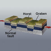
![Crustal block diagram with the down-dropped blocks labelled as "graben" and the upthrown blocks labelled as "horst" between faults](https://d9-wret.s3.us-west-2.amazonaws.com/assets/palladium/production/s3fs-public/styles/list_item/public/media/images/horst_graben.jpg?itok=29qmvyWk)
Graben
Graben
A down-dropped block of the earth's crust resulting from extension, or pulling, of the crust.
![Drawing of Isaac Newton sitting on a hill under an apple tree](https://d9-wret.s3.us-west-2.amazonaws.com/assets/palladium/production/s3fs-public/styles/list_item/public/media/images/GRAVITY.jpg?itok=d6xPV_io)
Gravity
Gravity
The attraction between two masses, such as the earth and an object on its surface. Commonly referred to as the acceleration of gravity. Changes in the gravity field can be used to infer information about the structure of the earth's lithosphere and upper mantle.
![Globe diagram with great circle around the globe with a dotted segment showing the shortest distance between two locations](https://d9-wret.s3.us-west-2.amazonaws.com/assets/palladium/production/s3fs-public/styles/list_item/public/media/images/great%20circle.gif?itok=RFiyAUjy)
Great circle
Great circle
The shortest path between two points on the surface of a sphere lies along a great circle.
![A photo of an asphalt ground with extensive cracking](https://d9-wret.s3.us-west-2.amazonaws.com/assets/palladium/production/s3fs-public/styles/list_item/public/media/images/lateral%20spreading%20and%20liquefaction.jpg?itok=OHq4d1Ob)
Ground failure
Ground failure
A general reference to landslides, liquefaction, lateral spreads, and any other consequence of shaking that affects the stability of the ground.
![Image of graph with seismic waves (squiggles) on it](https://d9-wret.s3.us-west-2.amazonaws.com/assets/palladium/production/s3fs-public/styles/list_item/public/media/images/earthquake%20seismogram.gif?itok=GAjpGT-Z)
Ground motion
Ground motion
The movement of the earth's surface from earthquakes or explosions. Ground motion is produced by waves that are generated by sudden slip on a fault or sudden pressure at the explosive source and travel through the earth and along its surface.
H
![Cross-section of the ground to show the layers: the top layer is brown with green grass and labelled "Surface," the second layer is green and labelled "Layer 1," the third layer is orange and labelled "Layer 2," and the bottom layer is significantly larger and has a grayscale gradient that gets lighter going downward and is labelled "Half-space."](https://d9-wret.s3.us-west-2.amazonaws.com/assets/palladium/production/s3fs-public/styles/list_item/public/media/images/halfspace.gif?itok=4IG1v1AG)
Halfspace
Halfspace
A mathematical model used to approximate the earth when performing some calculations in seismology. The model is much simpler than the real earth.
![Seismogram showing waves](https://d9-wret.s3.us-west-2.amazonaws.com/assets/palladium/production/s3fs-public/styles/list_item/public/media/images/harmonic_tremor.gif?itok=ff1fnMf5)
Harmonic tremor
Harmonic tremor
Continuous rhythmic earthquakes that can be detected by seismographs. Harmonic tremors often precede or accompany volcanic eruptions.
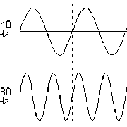
![Plot showing two waves, one with lower frequency labelled 440 Hz and another with higher frequency labelled 880 Hz](https://d9-wret.s3.us-west-2.amazonaws.com/assets/palladium/production/s3fs-public/styles/list_item/public/media/images/HERTZ.gif?itok=0T1LWH6h)
Hertz (Hz)
Hertz (Hz)
A unit of measurement named in honor of Heinrich Hertz, the German physicist who in 1887 first produced electromagnetic waves. Expresses the frequency in cycles per second; 1 Hz = 1 cycle of rise and fall of a wave per second .
![Geologic Time Scale...](https://d9-wret.s3.us-west-2.amazonaws.com/assets/palladium/production/s3fs-public/styles/list_item/public/vhp_img3232.gif?itok=aN3fOXFL)
Holocene
Holocene
The past 10,000 years. It includes most of the time since the end of the most recent ice age. If slip has occurred on a fault during the Holocene, the fault is commonly considered active.
![Crustal block diagram with the down-dropped blocks labelled as "graben" and the upthrown blocks labelled as "horst" between faults](https://d9-wret.s3.us-west-2.amazonaws.com/assets/palladium/production/s3fs-public/styles/list_item/public/media/images/horst_graben.jpg?itok=29qmvyWk)
Horst
Horst
A horst is found together with a graben in an extensional environment. The graben are the downdropped blocks and the horst are the upthrown blocks that lie next to the graben.
![A yellow rectangle with a diagonal line with a hypocenter explosion symbol on the line and an epicenter circle labelled on the top side of the rectangle directly above the hypocenter.](https://d9-wret.s3.us-west-2.amazonaws.com/assets/palladium/production/s3fs-public/styles/list_item/public/media/images/Epicenter%20Hypocenter.gif?itok=cUu0YtJk)
Hypocenter/focus
Hypocenter/focus
The point within the earth where an earthquake rupture starts. The epicenter is the point directly above it at the surface of the Earth. Also commonly termed the focus.
I
![Example of difference in shaking intensity of two earthquakes](https://d9-wret.s3.us-west-2.amazonaws.com/assets/palladium/production/s3fs-public/styles/list_item/public/thumbnails/image/intensity-Nisq.vs_.Northridge.jpg?itok=F9VRqbEi)
Intensity/Modified Mercalli Intensity Scale (MMI)
A number (written as a Roman numeral) describing the severity of an earthquake in terms of its effects on the earth's surface and on humans and their structures. Several scales exist, but the ones most commonly used in the United States are the Modified Mercalli scale and the Rossi-Forel scale. There are many intensities for an earthquake, depending on where you are, unlike the magnitude, which is one number for each earthquake.
![A map of Asia with colored dots. The earthquakes (colored dots) in the middle of the continent are intraplate events. Those near the ocean boundary are at the boundary between two plates (interplate).](https://d9-wret.s3.us-west-2.amazonaws.com/assets/palladium/production/s3fs-public/styles/list_item/public/media/images/intraplate%20events.gif?itok=uvWMXj7K)
Interplate
Interplate
Pertains to processes between the earth's crustal plates.
![A map of Asia with colored dots. The earthquakes (colored dots) in the middle of the continent are intraplate events. Those near the ocean boundary are at the boundary between two plates (interplate).](https://d9-wret.s3.us-west-2.amazonaws.com/assets/palladium/production/s3fs-public/styles/list_item/public/media/images/intraplate%20events.gif?itok=uvWMXj7K)
Interplate coupling
Interplate coupling
The ability of a fault between two plates to lock and accumulate stress. Strong interplate coupling means that the fault is locked and capable of accumulating stress, whereas weak coupling means that the fault is unlocked or only capable of accumulating low stress.
![A map of Asia with colored dots. The earthquakes (colored dots) in the middle of the continent are intraplate events. Those near the ocean boundary are at the boundary between two plates (interplate).](https://d9-wret.s3.us-west-2.amazonaws.com/assets/palladium/production/s3fs-public/styles/list_item/public/media/images/intraplate%20events.gif?itok=uvWMXj7K)
Intraplate
Intraplate
Pertains to processes within the plates.
![1811-1812 New Madrid Earthquakes Isoseismal Map](https://d9-wret.s3.us-west-2.amazonaws.com/assets/palladium/production/s3fs-public/styles/list_item/public/thumbnails/image/1811-1812_iso.gif?itok=8UVOWml5)
Isoseismal (line)
Isoseismal (line)
A contour or line on a map bounding points of equal intensity for a particular earthquake.
K
![Map of Iceland showing plate boundaries](https://d9-wret.s3.us-west-2.amazonaws.com/assets/palladium/production/s3fs-public/styles/list_item/public/media/images/iceland%20and%20plate%20motions%20%28kinematic%29.gif?itok=ncoRcepX)
Kinematic
Kinematic
The general movement patterns and directions of the earth's rocks that produce rock deformation.
L
![Photo of a hillside with a large amount of landmass sliding down the hill, right next to a town with buildings.](https://d9-wret.s3.us-west-2.amazonaws.com/assets/palladium/production/s3fs-public/styles/list_item/public/media/images/landslide.jpg?itok=iUIvbiT7)
Landslide
Landslide
A movement of surface material down a slope.
![Geologic Time Scale...](https://d9-wret.s3.us-west-2.amazonaws.com/assets/palladium/production/s3fs-public/styles/list_item/public/vhp_img3232.gif?itok=aN3fOXFL)
Late Quaternary
Late Quaternary
Refers informally to the past 0.5-1.0 million years. Faults that have slipped during this time are sometimes considered active.
![A photo of an asphalt ground with extensive cracking](https://d9-wret.s3.us-west-2.amazonaws.com/assets/palladium/production/s3fs-public/styles/list_item/public/media/images/lateral%20spreading%20and%20liquefaction.jpg?itok=OHq4d1Ob)
Lateral spread or flow
Terms referring to landslides that commonly form on gentle slopes and that have rapid fluid-like flow movement, like water.
![Graph with scattered dots with a diagonal line going downward from left to right in between the dots](https://d9-wret.s3.us-west-2.amazonaws.com/assets/palladium/production/s3fs-public/styles/list_item/public/media/images/least_squares.gif?itok=OSH1uUTb)
Least-squares fit
Least-squares fit
When plotting data points on a graph, the least-squares-fit is the line or curve that comes closest to going through all the points.
![Block diagram showing the left coastal block moving forward and parallel as the right block moves away](https://d9-wret.s3.us-west-2.amazonaws.com/assets/palladium/production/s3fs-public/styles/list_item/public/media/images/LEFT%20LATERAL.gif?itok=q8y4sVYu)
Left-lateral
Left-lateral
If you were to stand on the fault and look along its length, this is a type of strike-slip fault where the left block moves toward you and the right block moves away. See also right-lateral.
![Photo of a leaning transmission tower being held up by lifeline cables in a wooded area](https://d9-wret.s3.us-west-2.amazonaws.com/assets/palladium/production/s3fs-public/styles/list_item/public/media/images/lifelines.jpg?itok=ZU_CyB77)
Lifelines
Lifelines
Structures that are important or critical for a community to function, such as roadways, pipelines, powerlines, sewers, communications, and port facilities.
![Photo of sand being ejected through cracks, forming holes along railroad tracks](https://d9-wret.s3.us-west-2.amazonaws.com/assets/palladium/production/s3fs-public/styles/list_item/public/media/images/liquefaction.jpg?itok=wYCDbKSG)
Liquefaction
Liquefaction
A process by which water-saturated sediment temporarily loses strength and acts as a fluid, like when you wiggle your toes in the wet sand near the water at the beach. This effect can be caused by earthquake shaking.
![Cross-section of depths -16720 to -16780 with color-coded lithology sections and descriptions of each section](https://d9-wret.s3.us-west-2.amazonaws.com/assets/palladium/production/s3fs-public/styles/list_item/public/media/images/lithology.gif?itok=w1J_wl0G)
Lithology
Lithology
The description of rock composition (what it is made of) and texture.
![A diagram on a blue background showing a slice of the Earth's lithosphere, including continental crust (green), oceanic crust (maroon), asthenosphere (pink), and the upper mantle (yellow).](https://d9-wret.s3.us-west-2.amazonaws.com/assets/palladium/production/s3fs-public/styles/list_item/public/media/images/asthenosphere_0.jpg?itok=K_lU_W8j)
Lithosphere
Lithosphere
The outer solid part of the earth, including the crust and uppermost mantle. The lithosphere is about 100 km thick, although its thickness is age dependent (older lithosphere is thicker).The lithosphere below the crust is brittle enough at some locations to produce earthquakes by faulting, such as within a subducted oceanic plate.
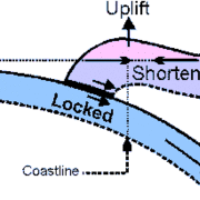
![Diagram of a locked fault (blue) going at a labelled coastline with a curbed](https://d9-wret.s3.us-west-2.amazonaws.com/assets/palladium/production/s3fs-public/styles/list_item/public/media/images/locked_fault.gif?itok=kNYTf-om)
Locked fault
Locked fault
A fault that is not slipping because frictional resistance on the fault is greater than the shear stress across the fault (it is stuck). Such faults may store strain for extended periods that is eventually released in an earthquake when frictional resistance is overcome.
![Diagram of a figure with a cube form made up of smaller cubes bent into waves and then going straight](https://d9-wret.s3.us-west-2.amazonaws.com/assets/palladium/production/s3fs-public/styles/list_item/public/media/images/LOVEWAVE.jpg?itok=3ktCaLpL)
Love wave
Love wave
A surface wave having a horizontal motion that is transverse (or perpendicular) to the direction the wave is traveling.
M
![Geologic time scale showing eras, periods, and notable events in terms of millions of years ago](https://d9-wret.s3.us-west-2.amazonaws.com/assets/palladium/production/s3fs-public/styles/list_item/public/media/images/geologic%20time%20scale%203.gif?itok=EqVi5YBG)
Ma
Ma
An abbreviation for one million years ago (Megannum).
![Diagram of a mid-ocean ridge showing magnetic polarity progression](https://d9-wret.s3.us-west-2.amazonaws.com/assets/palladium/production/s3fs-public/styles/list_item/public/media/images/magnetic_polrev.gif?itok=4U5v_aFO)
Magnetic polarity reversal
A change of the earth's magnetic field to the opposite polarity. This has occurred at irregular intervals during geologic time. Polarity reversals can be preserved in sequences of magnetized rocks and compared with standard polarity-change time scales to estimate geologic ages of the rocks. Rocks created along the oceanic spreading ridges commonly preserve this pattern of polarity reversals as they cool, and this pattern can be used to determine the rate of ocean ridge spreading. The reversal patterns recorded in the rocks are termed sea-floor magnetic lineaments.
![Magnitude plots with rainbow color gradients to compare the magnitude of two earthquakes](https://d9-wret.s3.us-west-2.amazonaws.com/assets/palladium/production/s3fs-public/styles/list_item/public/media/images/magnitude.gif?itok=445M8MX9)
Magnitude
Magnitude
A number that characterizes the relative size of an earthquake. Magnitude is based on measurement of the maximum motion recorded by a seismograph. Several scales have been defined, but the most commonly used are (1) local magnitude (ML), commonly referred to as "Richter magnitude", (2) surface-wave magnitude (Ms), (3) body-wave magnitude (Mb), and (4) moment magnitude (Mw). Scales 1-3 have limited range and applicability and do not satisfactorily measure the size of the largest earthquakes. The moment magnitude (Mw) scale, based on the concept of seismic moment, is uniformly applicable to all sizes of earthquakes but is more difficult to compute than the other types. All magnitude scales should yield approximately the same value for any given earthquake.
![Two fault lines with circles showing their aftershocks](https://d9-wret.s3.us-west-2.amazonaws.com/assets/palladium/production/s3fs-public/styles/list_item/public/media/images/landers%20and%20hector%20mine%20aftershocks.gif?itok=KnckVTgY)
Mainshock
Mainshock
The largest earthquake in a sequence, sometimes preceded by one or more foreshocks, and almost always followed by many aftershocks.
![Diagram showing a cone cross-section of the Earth with lithosphere (green), mantle (brown), and the core divided into the metallic liquid core (gray) and the solid inner core (black).](https://d9-wret.s3.us-west-2.amazonaws.com/assets/palladium/production/s3fs-public/styles/list_item/public/media/images/CORE.gif?itok=8YT25Rn6)
Mantle
Mantle
The part of the earth's interior between the metallic outer core and the crust.
![Map of the San Francisco Bay Area, California with colored spots showing liquefaction potential](https://d9-wret.s3.us-west-2.amazonaws.com/assets/palladium/production/s3fs-public/styles/list_item/public/media/images/liquefaction%20potential%20bay%20area.gif?itok=eExnxkTZ)
Microzonation
Microzonation
The identification of separate individual areas having different potentials for hazardous earthquake effects.
![A diagram on a blue background showing a slice of the Earth's lithosphere, including continental crust (green), oceanic crust (maroon), asthenosphere (pink), and the upper mantle (yellow).](https://d9-wret.s3.us-west-2.amazonaws.com/assets/palladium/production/s3fs-public/styles/list_item/public/media/images/asthenosphere_0.jpg?itok=K_lU_W8j)
Moho
Moho
The boundary between the crust and the mantle in the earth. This is a depth where seismic waves change velocity and there is also a change in chemical composition. Also termed the Mohorovicic' discontinuity after the Croatian seismologist Andrija Mohorovicic' (1857-1936) who discovered it. The boundary is between 25 and 60 km deep beneath the continents and between 5 and 8 km deep beneath the ocean floor.
![9 sets of two vectors](https://d9-wret.s3.us-west-2.amazonaws.com/assets/palladium/production/s3fs-public/styles/list_item/public/media/images/moment_tensor.gif?itok=ZePP76RV)
Moment tensor
Moment tensor
A mathematical representation of the movement on a fault during an earthquake, comprising of nine generalized couples, or nine sets of two vectors. The tensor depends of the source strength and fault orientation. It is often represented with "beach balls" just like the focal mechanism (or fault plane solution).
N
![Two graphs](https://d9-wret.s3.us-west-2.amazonaws.com/assets/palladium/production/s3fs-public/styles/list_item/public/media/images/natural_freq.gif?itok=FHavJdT0)
Natural frequency
Natural frequency
The frequency at which a particular object or system vibrates when pushed by a single force or impulse, and not influenced by other external forces or by damping. If you hold a slinky by one end and let it hang down and then give it one push up from the bottom, the rate of up-and-down motion is its natural frequency.
![cartoon of two blocks of offset earth crust at an angle](https://d9-wret.s3.us-west-2.amazonaws.com/assets/palladium/production/s3fs-public/styles/list_item/public/thumbnails/image/eq-ed-fault-labeled.gif?itok=1m21vtRX)
Normal fault/dip-slip fault/thrust fault
Normal, or dip-slip, faults are inclined fractures where the blocks have mostly shifted vertically. If the rock mass above an inclined fault moves down, the fault is termed normal, whereas if the rock above the fault moves up, the fault is termed reverse. A thrust fault is a reverse fault with a dip of 45 degrees or less. Oblique-slip faults have significant components of different slip styles.
![A diagram showing three stress types on cubes: the first is labelled "tensional stress" with arrows pointed outwards, the second is labelled "compressional stress" with arrows pointed inwards, and the third is labelled "shear stress" with arrows pointed parallel to each other.](https://d9-wret.s3.us-west-2.amazonaws.com/assets/palladium/production/s3fs-public/styles/list_item/public/media/images/stress_types.gif?itok=V3BSY5b0)
Normal stress
Normal stress
That stress component perpendicular to a given plane. If you lean against a door after you close it, you are applying normal stress to the door. Normal stress can either be compressional or tensional.
O
![Diagram showing an oceanic ridge forming as the lithosphere separates](https://d9-wret.s3.us-west-2.amazonaws.com/assets/palladium/production/s3fs-public/styles/list_item/public/media/images/oceanic_spreading.gif?itok=LA8_x9bQ)
Oceanic spreading ridge
The fracture zone along the ocean bottom where molten mantle material comes to the surface, thus creating new crust. This fracture can be seen beneath the ocean as a line of ridges that form as molten rock reaches the ocean bottom and solidifies.
![Diagram showing an oceanic ridge forming as the lithosphere separates](https://d9-wret.s3.us-west-2.amazonaws.com/assets/palladium/production/s3fs-public/styles/list_item/public/media/images/oceanic_spreading.gif?itok=LA8_x9bQ)
Oceanic trench
Oceanic trench
A linear depression of the sea floor caused by the subduction of one plate under another.
P
![Diagram showing P waves (small jolt or light shaking or not felt), S waves (larger jolt or strong shaking), and surface waves (rolling motion))](https://d9-wret.s3.us-west-2.amazonaws.com/assets/palladium/production/s3fs-public/styles/list_item/public/media/images/p%20waves%20s%20waves%20surface%20waves.gif?itok=jrbT91Cl)
P wave/compressional wave
A P wave, or compressional wave, is a seismic body wave that shakes the ground back and forth in the same direction and the opposite direction as the direction the wave is moving.
![USGS and university geologists standing on trench walls and using ladder to look at and study the wall](https://d9-wret.s3.us-west-2.amazonaws.com/assets/palladium/production/s3fs-public/styles/list_item/public/media/images/Seattle%20Fault%20Strand.jpg?itok=-SnJgIcu)
Paleoseismicity
Paleoseismicity
Earthquakes recorded geologically, most of them unknown from human descriptions or seismograms. Geologic records of past earthquakes can include faulted layers of sediment and rock, injections of liquefied sand, landslides, abruptly raised or lowered shorelines, and tsunami deposits.
![Person in yellow hat sitting on the ground and looking into a green valley with clouds surrounding snow-topped mountains](https://d9-wret.s3.us-west-2.amazonaws.com/assets/palladium/production/s3fs-public/styles/list_item/public/media/images/looking%20at%20mountain.jpg?itok=YqzQsihL)
Pedogenic
Pedogenic
Pedogenic means pertaining to processes that add, transfer, transform, or remove soil constituents.
![Black background with a green wave and a white arrow pointing across one concave and one convex hump to indicate a period](https://d9-wret.s3.us-west-2.amazonaws.com/assets/palladium/production/s3fs-public/styles/list_item/public/media/images/PERIOD.gif?itok=jQbBQIrY)
Period
Period
The time interval required for one full cycle of a wave.
![World map with different colored outlines to show tectonic plates](https://d9-wret.s3.us-west-2.amazonaws.com/assets/palladium/production/s3fs-public/styles/list_item/public/media/images/plate_tectonics.gif?itok=keI2h7DX)
Plate tectonics
Plate tectonics
The theory supported by a wide range of evidence that considers the earth's crust and upper mantle to be composed of several large, thin, relatively rigid plates that move relative to one another. Slip on faults that define the plate boundaries commonly results in earthquakes. Several styles of faults bound the plates, including thrust faults along which plate material is subducted or consumed in the mantle, oceanic spreading ridges along which new crustal material is produced, and transform faults that accommodate horizontal slip (strike slip) between adjoining plates.
![Geologic Time Scale...](https://d9-wret.s3.us-west-2.amazonaws.com/assets/palladium/production/s3fs-public/styles/list_item/public/vhp_img3232.gif?itok=aN3fOXFL)
Pleistocene
Pleistocene
The time period between about 10,000 years before present and about 1,650,000 years before present. As a descriptive term applied to rocks or faults, it marks the period of rock formation or the time of most recent fault slip, respectively. Faults of Pleistocene age may be considered active though their activity rates are commonly lower than younger faults.
Poisson distribution
A probability distribution that characterizes discrete events occurring independently of one another in time.
Q
![Photo of ripples in a pond with the reflection of a cloudy sky](https://d9-wret.s3.us-west-2.amazonaws.com/assets/palladium/production/s3fs-public/styles/list_item/public/media/images/pond%20ripples%20attenuation.jpg?itok=OETcjntU)
Q
Q
The inverse of attenuation. A high Q means a low attenuation.
![Geologic time scale showing eras, periods, and notable events in terms of millions of years ago](https://d9-wret.s3.us-west-2.amazonaws.com/assets/palladium/production/s3fs-public/styles/list_item/public/media/images/geologic%20time%20scale%203.gif?itok=EqVi5YBG)
Quaternary
Quaternary
The geologic time period comprising about the last 1.65 million years.
R
![A diagram with 3 yellow squares with arrows pointing to indicate steps. The first yellow square has all white dots and is labelled "Time 1: pure parent isotope," the second/middle yellow square has half white dots and half green dots (labelled as the daughter isotopes) and is labelled "After 1 half life: 1/2 parent and 1/2 daughter isotope," and the third yellow square has a quarter white dots and three-quarters green dots and is labelled "After 2 half lives: 1/4 parent and 3/4 daughter isotopes."](https://d9-wret.s3.us-west-2.amazonaws.com/assets/palladium/production/s3fs-public/styles/list_item/public/media/images/CARBON14.gif?itok=AwsGvj4p)
Radiometric
Radiometric
Pertaining to the measurement of geologic time by the analysis of certain radioisotopes in rocks and their known rates of decay.
![Diagram of a figure with a cube form made up of smaller cubes bent into waves and then going straight](https://d9-wret.s3.us-west-2.amazonaws.com/assets/palladium/production/s3fs-public/styles/list_item/public/media/images/LOVEWAVE.jpg?itok=3ktCaLpL)
Rayleigh wave
Rayleigh wave
A seismic surface wave causing the ground to shake in an elliptical motion, with no transverse, or perpendicular, motion.
![A stress vs time graph showing fault strength and an offset across fault vs time graph](https://d9-wret.s3.us-west-2.amazonaws.com/assets/palladium/production/s3fs-public/styles/list_item/public/media/images/recurrence_interval.gif?itok=ozqpsZIc)
Recurrence interval/return period
The recurrence interval, or return period, is the average time span between earthquake occurrences on a fault or in a source zone.
![Illustration showing a wave reflecting off of the boundary between Rock Type 1 and Rock Type 2](https://d9-wret.s3.us-west-2.amazonaws.com/assets/palladium/production/s3fs-public/styles/list_item/public/media/images/reflected%20wave.gif?itok=PGZJTX0Z)
Reflection
Reflection
The energy or wave from an earthquake that has been returned (reflected) from an boundary between two different materials within the earth, just as a mirror reflects light.
![Illustration showing an angled downward vector in two scenarios: The first shows a vector going through Rock Type 1 and then getting a less steep slope in Rock Type 2, meaning the velocity in rock type 2 is greater than velocity in rock type 1; and the second shows a vector going through Rock Type 1 and then getting a more steep slope in Rock Type 2, meaning the velocity in rock type 2 is less than velocity in rock type 1](https://d9-wret.s3.us-west-2.amazonaws.com/assets/palladium/production/s3fs-public/styles/list_item/public/media/images/refraction%20.gif?itok=L-6PPNgO)
Refraction
Refraction
Refraction is (1) the deflection, or bending, of the ray path of a seismic wave caused by its passage from one material to another having different elastic properties. (2) bending of a tsunami wave front owing to variations in the water depth along a coastline.
![Graph with scattered dots with a diagonal line going downward from left to right in between the dots](https://d9-wret.s3.us-west-2.amazonaws.com/assets/palladium/production/s3fs-public/styles/list_item/public/media/images/least_squares.gif?itok=OSH1uUTb)
Regression analysis
Regression analysis
A statistical technique applied to data to determine, for predictive purposes, the degree of correlation of a dependent variable with one or more independent variables, in other words, to see if there is a strong or weak cause and effect relationship between to things. See also: least-squares.
![Graph titled "Residuals" with "Residual" on the y-axis and "X variable" on the x-axis with a scattering of diamonds plotted](https://d9-wret.s3.us-west-2.amazonaws.com/assets/palladium/production/s3fs-public/styles/list_item/public/media/images/RESIDUAL.gif?itok=T5wvFFZd)
Residual
Residual
The difference between the measured and predicted values of some quantity.
![Illustration showing distance, magnitude, and amplitude used in the Richter scale](https://d9-wret.s3.us-west-2.amazonaws.com/assets/palladium/production/s3fs-public/styles/list_item/public/media/images/richter_scale.gif?itok=eM4Y1etE)
Richter scale
Richter scale
The Richter magnitude scale was developed in 1935 by Charles F. Richter of the California Institute of Technology as a mathematical device to compare the size of earthquakes. The magnitude of an earthquake is determined from the logarithm of the amplitude of waves recorded by seismographs. Adjustments are included for the variation in the distance between the various seismographs and the epicenter of the earthquakes. On the Richter Scale, magnitude is expressed in whole numbers and decimal fractions. For example, a magnitude 5.3 might be computed for a moderate earthquake, and a strong earthquake might be rated as magnitude 6.3. Because of the logarithmic basis of the scale, each whole number increase in magnitude represents a tenfold increase in measured amplitude; as an estimate of energy, each whole number step in the magnitude scale corresponds to the release of about 31 times more energy than the amount associated with the preceding whole number value.
![Block diagram showing the right coastal block moving forward and parallel as the left block moves away](https://d9-wret.s3.us-west-2.amazonaws.com/assets/palladium/production/s3fs-public/styles/list_item/public/media/images/RIGHTLAT.gif?itok=gs07FcLj)
Right-lateral
Right-lateral
If you were to stand on the fault and look along its length, this is a type of strike-slip fault where the right block moves toward you and the left block moves away.
![Map showing the ring of fire in red from the east side of Australia, up the east side of Asia, down the west coast of North America, and down the west coast of South America.](https://d9-wret.s3.us-west-2.amazonaws.com/assets/palladium/production/s3fs-public/styles/list_item/public/media/images/ringoffire.gif?itok=ZAgs6GS7)
Ring of Fire
Ring of Fire
The "Ring of Fire", also called the Circum-Pacific belt, is the zone of earthquakes surrounding the Pacific Ocean- about 90% of the world's earthquakes occur there. The next most seismic region (5-6% of earthquakes) is the Alpide belt (extends from Mediterranean region, eastward through Turkey, Iran, and northern India.
![Wide arrow with snapshots of a rupture front moving across a fault surface.](https://d9-wret.s3.us-west-2.amazonaws.com/assets/palladium/production/s3fs-public/styles/list_item/public/media/images/rupture_front.jpg?itok=c8a47qHn)
Rupture front
Rupture front
The instantaneous boundary between the slipping and locked parts of a fault during an earthquake. Rupture in one direction on the fault is referred to as unilateral. Rupture may radiate outward in a circular manner or it may radiate toward the two ends of the fault from an interior point, behavior referred to as bilateral.
![Wide arrow with snapshots of a rupture front moving across a fault surface.](https://d9-wret.s3.us-west-2.amazonaws.com/assets/palladium/production/s3fs-public/styles/list_item/public/media/images/rupture_front.jpg?itok=c8a47qHn)
Rupture velocity
Rupture velocity
The speed at which a rupture front moves across the surface of the fault during an earthquake.
S
![Diagram of S waves showing a block diagram with equal wave sizes](https://d9-wret.s3.us-west-2.amazonaws.com/assets/palladium/production/s3fs-public/styles/list_item/public/media/images/s%20waves.gif?itok=cTDlX4lZ)
S wave/shear wave
S wave/shear wave
An S wave, or shear wave, is a seismic body wave that shakes the ground back and forth perpendicular to the direction the wave is moving.
![Photo of light gray sand with a dark hole](https://d9-wret.s3.us-west-2.amazonaws.com/assets/palladium/production/s3fs-public/styles/list_item/public/media/images/SANDBOIL.jpg?itok=tLsDuWi5)
Sand boil
Sand boil
Sand and water that come out onto the ground surface during an earthquake as a result of liquefaction at shallow depth.
![Diagram showing an oceanic ridge forming as the lithosphere separates](https://d9-wret.s3.us-west-2.amazonaws.com/assets/palladium/production/s3fs-public/styles/list_item/public/media/images/oceanic_spreading.gif?itok=LA8_x9bQ)
Sea-floor spreading
Sea-floor spreading
Sea-floor spreading is what happens at the mid-oceanic ridge where a divergent boundary is causing two plates to move away from one another resulting in spreading of the sea floor. As the plates move apart, new material wells up and cools onto the edge of the plates.
![Photo of snowy mountains in the background with pine trees in the foreground](https://d9-wret.s3.us-west-2.amazonaws.com/assets/palladium/production/s3fs-public/styles/list_item/public/media/images/secular%20mountains.jpg?itok=uPzXr6iN)
Secular
Secular
Refers to long-term changes that take place slowly and imperceptibly. Commonly used to describe changes in elevation, tilt, and stress or strain rates that are related to long-term tectonic deformation. For example, a mountain that is growing is getting taller so slowly that we cannot see it happen, but if we were to measure the elevation one year and then the next, we could see that it has grown taller.
![Outline of California showing the line of the San Andreas](https://d9-wret.s3.us-west-2.amazonaws.com/assets/palladium/production/s3fs-public/styles/list_item/public/media/images/segmentation.gif?itok=kW6Pidl8)
Segmentation
Segmentation
The breaking up of a fault along its length into several smaller faults. This can happen as a result of other faults crossing it, topography changes, or bends in the strike of the faults. Segmentation can limit the length of faulting in a single earthquake to some fraction of the total fault length, thus also limiting the size of the earthquake.
![Illustration titled "Seiche in Lake Geneva (Switzerland)" with a labeled node in Lake Geneva and showing "One wavelength equals twice the length of the lake"](https://d9-wret.s3.us-west-2.amazonaws.com/assets/palladium/production/s3fs-public/styles/list_item/public/media/images/seiche%20in%20lake%20geneva.jpg?itok=uAp50tnI)
Seiche
Seiche
The sloshing of a closed body of water from earthquake shaking. Swimming pools often have seiches during earthquakes.
![Diagram of cross-sections with labelled gaps in the San Andreas Fault](https://d9-wret.s3.us-west-2.amazonaws.com/assets/palladium/production/s3fs-public/styles/list_item/public/media/images/seismic_gap.gif?itok=-E81DAa1)
Seismic gap
Seismic gap
A section of a fault that has produced earthquakes in the past but is now quiet. For some seismic gaps, no earthquakes have been observed historically, but it is believed that the fault segment is capable of producing earthquakes on some other basis, such as plate-motion information or strain measurements.
![Diagram showing a blob shape with a D and an arrow pointing right and a labelled reupture. The height is labelled "W" and the length is "L." The top line is labelled "Surface" and the bottom line is labelled "Base of seismogenic zone"](https://d9-wret.s3.us-west-2.amazonaws.com/assets/palladium/production/s3fs-public/styles/list_item/public/media/images/seismogenic%20zone.gif?itok=lSI-9IW3)
Seismic moment
Seismic moment
A measure of the size of an earthquake based on the area of fault rupture, the average amount of slip, and the force that was required to overcome the friction sticking the rocks together that were offset by faulting. Seismic moment can also be calculated from the amplitude spectra of seismic waves.
![Illustration of a person hammering a plate on the ground. The ground has two layers: yellow sediment and gray bedrock. The hammering is creating arrows, one angled down from the point of impact and multiple angled up evenly spaced apart after hitting the bedrock layer.](https://d9-wret.s3.us-west-2.amazonaws.com/assets/palladium/production/s3fs-public/styles/list_item/public/media/images/seismic_refraction.jpg?itok=BJs7sfiP)
Seismic refraction
Seismic refraction
A seismic refraction or seismic reflection line is a set of seismographs usually lined up along the earth's surface to record seismic waves generated by an explosion for the purpose of recording reflections and refractions of these waves from velocity discontinuities within the earth. The data collected can be used to infer the internal structure of the earth.
![wiggly red line across page from left to right](https://d9-wret.s3.us-west-2.amazonaws.com/assets/palladium/production/s3fs-public/styles/list_item/public/media/images/P%26S-waves.gif?h=9e80746d&itok=jnSOHLid)
Seismic wave
Seismic wave
An elastic wave generated by an impulse such as an earthquake or an explosion. Seismic waves may travel either along or near the earth's surface (Rayleigh and Love waves) or through the earth's interior (P and S waves).
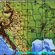
![Map of the central US (Missouri, Illinois, Kentucky, Tennessee) with red lines and red, yellow, and blue circles representing earthquake magnitude](https://d9-wret.s3.us-west-2.amazonaws.com/assets/palladium/production/s3fs-public/styles/list_item/public/media/images/seismic_zone.gif?itok=RFI0-2ri)
Seismic zone
Seismic zone
An area of seismicity probably sharing a common cause. Example: "The New Madrid Seismic Zone."
![Map of the continuous United States with dots marking seismic events, with the majority of seismicity on the west coast](https://d9-wret.s3.us-west-2.amazonaws.com/assets/palladium/production/s3fs-public/styles/list_item/public/media/images/seismicity_0.jpg?itok=CMsEJ43D)
Seismicity
Seismicity
The geographic and historical distribution of earthquakes.
![Diagram showing a blob shape with a D and an arrow pointing right and a labelled reupture. The height is labelled "W" and the length is "L." The top line is labelled "Surface" and the bottom line is labelled "Base of seismogenic zone"](https://d9-wret.s3.us-west-2.amazonaws.com/assets/palladium/production/s3fs-public/styles/list_item/public/media/images/seismogenic%20zone.gif?itok=lSI-9IW3)
Seismogenic
Seismogenic
Capable of generating earthquakes. The base of the seismogenic zone is the top of the more ductile asthenosphere.
![Seismic waves](https://d9-wret.s3.us-west-2.amazonaws.com/assets/palladium/production/s3fs-public/styles/list_item/public/media/images/seismogram.gif?itok=rVLtF5xi)
Seismogram
Seismogram
A record written by a seismograph in response to ground motions produced by an earthquake, explosion, or other ground-motion sources.
![Black and white side-view photo of Charles Richter looking at a paper on a desk](https://d9-wret.s3.us-west-2.amazonaws.com/assets/palladium/production/s3fs-public/styles/list_item/public/media/images/charles-richter.jpg?itok=Mm7StUN3)
Seismology
Seismology
The study of earthquakes and the structure of the earth, by both naturally and artificially generated seismic waves.
Seismometer/seismograph
A seismometer, or seismograph, is an instrument used to detect and record earthquakes. Generally, it consists of a mass attached to a fixed base. During an earthquake, the base moves and the mass does not. The motion of the base with respect to the mass is commonly transformed into an electrical voltage. The electrical voltage is recorded on paper, magnetic tape, or another recording medium. This record is proportional to the motion of the seismometer mass relative to the earth, but it can be mathematically converted to a record of the absolute motion of the ground. Seismograph generally refers to the seismometer and its recording device as a single unit.
![Half circle diagram of showing the relationship between angles from an earthquake and the P-wave shadow zone](https://d9-wret.s3.us-west-2.amazonaws.com/assets/palladium/production/s3fs-public/styles/list_item/public/media/images/shadow_zone.gif?itok=_PfQJWvf)
Shadow zone
Shadow zone
The area of the earth from angular distances of 104 to 140 degrees from a given earthquake that does not receive any direct P waves. The shadow zone results from S waves being stopped entirely by the liquid core and P waves being bent (refracted) by the liquid core.
![A diagram showing three stress types on cubes: the first is labelled "tensional stress" with arrows pointed outwards, the second is labelled "compressional stress" with arrows pointed inwards, and the third is labelled "shear stress" with arrows pointed parallel to each other.](https://d9-wret.s3.us-west-2.amazonaws.com/assets/palladium/production/s3fs-public/styles/list_item/public/media/images/stress_types.gif?itok=V3BSY5b0)
Shear stress
Shear stress
The stress component parallel to a given surface, such as a fault plane, that results from forces applied parallel to the surface or from remote forces transmitted through the surrounding rock.
![Diagram showing a descending slab in yellow with the associated dip angle, flow pressure, and gravitational body force vectors](https://d9-wret.s3.us-west-2.amazonaws.com/assets/palladium/production/s3fs-public/styles/list_item/public/media/images/SLAB.gif?itok=zCNx54N_)
Slab
Slab
The oceanic crustal plate that underthrusts the continental plate in a subduction zone and is consumed by the earth's mantle.
![Photo of a rock outcrop with labelled rake and strike vectors](https://d9-wret.s3.us-west-2.amazonaws.com/assets/palladium/production/s3fs-public/styles/list_item/public/media/images/slickensides.jpg?itok=kj-F1_q6)
Slickensides
Slickensides
Polished striated rock surfaces caused by one rock mass moving across another on a fault.
![Slip model with a rainbow color gradient showing the slip over the depth and distance along strike](https://d9-wret.s3.us-west-2.amazonaws.com/assets/palladium/production/s3fs-public/styles/list_item/public/media/images/landers%20slip%20model.jpg?itok=RhmGZiwM)
Slip
Slip
The relative displacement of formerly adjacent points on opposite sides of a fault, measured on the fault surface.
![Slip model with a rainbow color gradient showing the slip over the depth and distance along strike](https://d9-wret.s3.us-west-2.amazonaws.com/assets/palladium/production/s3fs-public/styles/list_item/public/media/images/landers%20slip%20model.jpg?itok=RhmGZiwM)
Slip model
Slip model
A kinematic model that describes the amount, distribution, and timing of slip associated with an earthquake.
![Map of coast with dark gray as the land and dark blue as the ocean with different colored lines for slip rate values across the land](https://d9-wret.s3.us-west-2.amazonaws.com/assets/palladium/production/s3fs-public/styles/list_item/public/media/images/slip_rate.gif?itok=xUvLNuhI)
Slip rate
Slip rate
How fast the two sides of a fault are slipping relative to one another, as determined from geodetic measurements, from offset man-made structures, or from offset geologic features whose age can be estimated. It is measured parallel to the predominant slip direction or estimated from the vertical or horizontal offset of geologic markers.
![Soil profile with grass and dark brown soil at the top, followed by a light tan soil, then a thinner reddish soil band, and another tan layer of soil at the bottom.](https://d9-wret.s3.us-west-2.amazonaws.com/assets/palladium/production/s3fs-public/styles/list_item/public/media/images/soilprofile.jpg?itok=bpp-O2PE)
Soil
Soil
Soil is (1) In engineering, all unconsolidated material above bedrock. (2) In soil science, naturally occurring layers of mineral and (or) organic constituents that differ from the underlying parent material in their physical, chemical, mineralogical, and morphological character because of pedogenic processes (3) In other words, dirt.
![Soil profile with grass and dark brown soil at the top, followed by a light tan soil, then a thinner reddish soil band, and another tan layer of soil at the bottom.](https://d9-wret.s3.us-west-2.amazonaws.com/assets/palladium/production/s3fs-public/styles/list_item/public/media/images/soilprofile.jpg?itok=bpp-O2PE)
Soil profile
Soil profile
The vertical arrangement of layers of soil down to the bedrock.
![Block diagram with a labelled earthquake source shown as a circle on the fault plane and directly underneath the center of the produced circular, seismic waves](https://d9-wret.s3.us-west-2.amazonaws.com/assets/palladium/production/s3fs-public/styles/list_item/public/media/images/SOURCE.gif?itok=1T2Eahlk)
Source
Source
The term for the released forces that generate acoustic or seismic waves, also called the earthquake source.
![Graph with 'Period (s)' on the x-axis and 'Spectral Acceleration (g)' on the y-axis. There are several lines plotted in different colors: 'Rock Att. Relationship' in red, 'Soil Att. Relationship' in blue, and 'EQ Moquegua record' in green.](https://d9-wret.s3.us-west-2.amazonaws.com/assets/palladium/production/s3fs-public/styles/list_item/public/media/images/spectral_accel.gif?itok=uvsLlba2)
Spectral acceleration (SA)
PGA (peak acceleration) is what is experienced by a particle on the ground. SA (spectral acceleration) is approximately what is experienced by a building, as modeled by a particle on a massless vertical rod having the same natural period of vibration as the building.
![Graph with 'Frequency (Hz)' on the x-axis and 'Relative Amplitude (dB)' on the y-axis. Colored waves show different spectrum amplitudes.](https://d9-wret.s3.us-west-2.amazonaws.com/assets/palladium/production/s3fs-public/styles/list_item/public/media/images/SPECTRUM.gif?itok=PXfkf7tW)
Spectrum
Spectrum
A curve showing amplitude and phase as a function of frequency or period, or how much of each type of shaking there is from an earthquake.
![Bell curve with red in the middle, green in the opposite middle layers, and blue in the opposite outside layers](https://d9-wret.s3.us-west-2.amazonaws.com/assets/palladium/production/s3fs-public/styles/list_item/public/media/images/standard_dev.gif?itok=qYVsFCgN)
Standard deviation
Standard deviation
How much a set of data is different from the curve it should make when plotted on a graph. Or, the square root of the average of the squares of deviations about the mean of a set of data. Standard deviation is a statistical measure of spread or variability.
![Photo of L-shaped equipment standing on tan gravel and in front of a tree.](https://d9-wret.s3.us-west-2.amazonaws.com/assets/palladium/production/s3fs-public/styles/list_item/public/media/images/STATION-EMS.jpg?itok=JUxmRgAF)
Station
Station
The place where a geophysical instrument is located.
![Block with a mass of 'm' being pulled by a spring at a velocity of 'v'](https://d9-wret.s3.us-west-2.amazonaws.com/assets/palladium/production/s3fs-public/styles/list_item/public/media/images/stickslip_0.gif?itok=sEMJ6unU)
Stick-slip
Stick-slip
The fast movement that occurs between two sides of a fault when the two sides of the fault become unstuck. The rock becomes distorted, or bent, but holds its position until the earthquake occurs. When the rock snaps back into an unstrained position it is called elastic rebound. Stick-slip displacement on a fault radiates energy in the form of seismic waves, creating an earthquake.
![Two figures: The one on the left has black circles in a 6x6 grid and labelled "Fixed dot size. Fixed dot spacing". The other has black circles scattered and is labelled "1st Order Stochastic. Fixed dot size. Variable dot spacing".](https://d9-wret.s3.us-west-2.amazonaws.com/assets/palladium/production/s3fs-public/styles/list_item/public/media/images/stochastic.gif?itok=aAXF6EKL)
Stochastic
Stochastic
A term applied to processes that have random characteristics.
![Three diagrams showing the different types of strain starting with a straight rectangular prism. "Brittle Strain" is showing as the prism breaking. "Ductile Strain" is shown as the prism bending in one spot and nearing an L shape. "Elastic Strain" is shown as slight bending in two spots in opposite directions nearing a slight S shape.](https://d9-wret.s3.us-west-2.amazonaws.com/assets/palladium/production/s3fs-public/styles/list_item/public/media/images/strain%20types.gif?itok=xzIbRPUo)
Strain
Strain
The small changes in length and volume associated with deformation of the earth by tectonic stresses or by the passage of seismic waves.
![Three diagrams showing the different types of strain starting with a straight rectangular prism. "Brittle Strain" is showing as the prism breaking. "Ductile Strain" is shown as the prism bending in one spot and nearing an L shape. "Elastic Strain" is shown as slight bending in two spots in opposite directions nearing a slight S shape.](https://d9-wret.s3.us-west-2.amazonaws.com/assets/palladium/production/s3fs-public/styles/list_item/public/media/images/strain%20types.gif?itok=xzIbRPUo)
Strain rate
Strain rate
How fast the lithosphere is being deformed from plate tectonic movement.
![A diagram showing three stress types on cubes: the first is labelled "tensional stress" with arrows pointed outwards, the second is labelled "compressional stress" with arrows pointed inwards, and the third is labelled "shear stress" with arrows pointed parallel to each other.](https://d9-wret.s3.us-west-2.amazonaws.com/assets/palladium/production/s3fs-public/styles/list_item/public/media/images/stress_types.gif?itok=V3BSY5b0)
Stress
Stress
The force per unit area acting on a plane within a body. Six values are required to characterize completely the stress at a point: three normal components and three shear components.
![A stress vs time graph showing fault strength and an offset across fault vs time graph](https://d9-wret.s3.us-west-2.amazonaws.com/assets/palladium/production/s3fs-public/styles/list_item/public/media/images/recurrence_interval.gif?itok=ozqpsZIc)
Stress drop
Stress drop
The difference between the stress across a fault before and after an earthquake.
![3 diagrams: At the top is a crustal block diagram showing how strike direction from North along a fault. At the bottom left is a figure showing the strike angle as the angle between North and the fault plane with dip direction pointing away from the fault plane. At the bottom right is a circle with North, East, South, and West and their respective strikes when going clockwise from North: 0, 90, 180, 270.](https://d9-wret.s3.us-west-2.amazonaws.com/assets/palladium/production/s3fs-public/styles/list_item/public/media/images/STRIKE.gif?itok=-RLqUOtR)
Strike
Strike
The trend or bearing, relative to north, of the line defined by the intersection of a planar geologic surface (for example, a fault or a bed) and a horizontal surface such as the ground.
![Three diagrams showing types of faults. Strike-slip is shown with the blocks of crust moving parallel to each other. The normal fault is shown with a fault at an angle and the overhanging block sliding downward. The thrust fault is shown with the same angle of the fault but the overhanging block is sliding upwards.](https://d9-wret.s3.us-west-2.amazonaws.com/assets/palladium/production/s3fs-public/styles/list_item/public/media/images/FAULT.gif?itok=Jrls3csY)
Strike-slip fault
Strike-slip fault
A vertical (or nearly vertical) fracture where the blocks have mostly moved horizontally. If the block opposite an observer looking across the fault moves to the right, the slip style is termed right lateral; if the block moves to the left, the motion is termed left lateral.
![Photo of large house with damage and debris on the ground](https://d9-wret.s3.us-west-2.amazonaws.com/assets/palladium/production/s3fs-public/styles/list_item/public/media/images/strongmotion.jpg?itok=Un7sJ-xC)
Strong motion
Strong motion
Ground motion of sufficient amplitude and duration to be potentially damaging to a building or other structure.
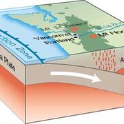
![Block diagram showing the Juan de Fuca Plate being subducted under the North America Plate and creating the Mt. St. Helens and Mt. Hood volcanoes.](https://d9-wret.s3.us-west-2.amazonaws.com/assets/palladium/production/s3fs-public/styles/list_item/public/media/images/subduction%20zone.jpg?itok=VcYq9tmr)
Subduction
Subduction
The process of the oceanic lithosphere colliding with and descending beneath the continental lithosphere.
![Block diagram showing the Juan de Fuca Plate being subducted under the North America Plate and creating the Mt. St. Helens and Mt. Hood volcanoes.](https://d9-wret.s3.us-west-2.amazonaws.com/assets/palladium/production/s3fs-public/styles/list_item/public/media/images/subduction%20zone.jpg?itok=VcYq9tmr)
Subduction zone
Subduction zone
The place where two lithospheric plates come together, one riding over the other. Most volcanoes on land occur parallel to and inland from the boundary between the two plates.
![Photo of a large crack of tan, sandy-looking ground viewed from a window](https://d9-wret.s3.us-west-2.amazonaws.com/assets/palladium/production/s3fs-public/styles/list_item/public/media/images/hector%20mine%20surface%20rupture.jpg?itok=AjZzoY5i)
Surface faulting
Surface faulting
Displacement that reaches the earth's surface during slip along a fault. Commonly occurs with shallow earthquakes, those with an epicenter less than 20 km. Surface faulting also may accompany aseismic creep or natural or man-induced subsidence.
![Block diagram showing equal waves throughout](https://d9-wret.s3.us-west-2.amazonaws.com/assets/palladium/production/s3fs-public/styles/list_item/public/media/images/surface_waves.gif?itok=SMIck4FP)
Surface wave
Surface wave
A seismic wave that is trapped near the surface of the earth.
T
![World map with different colored outlines to show tectonic plates](https://d9-wret.s3.us-west-2.amazonaws.com/assets/palladium/production/s3fs-public/styles/list_item/public/media/images/plate_tectonics.gif?itok=keI2h7DX)
Tectonic
Tectonic
Refers to rock-deforming processes and resulting structures that occur over large sections of the lithosphere.
![World map with different colored outlines to show tectonic plates](https://d9-wret.s3.us-west-2.amazonaws.com/assets/palladium/production/s3fs-public/styles/list_item/public/media/images/plate_tectonics.gif?itok=keI2h7DX)
Tectonic plates
Tectonic plates
The large, thin, relatively rigid plates that move relative to one another on the outer surface of the Earth.
![Globe with blue ocean and green continents. A red triangle is labelled "Seismograph Station" with a yellow star labelled "Local Earthquake" a bit south, both in California. There is another yellow star in the middle of the Atlantic Ocean labelled "Teleseismic Earthquake".](https://d9-wret.s3.us-west-2.amazonaws.com/assets/palladium/production/s3fs-public/styles/list_item/public/media/images/teleseismic.gif?itok=hPzfRk8O)
Teleseismic
Teleseismic
Pertains to earthquakes at distances greater than 1,000 km from the measurement site.
![A diagram showing three stress types on cubes: the first is labelled "tensional stress" with arrows pointed outwards, the second is labelled "compressional stress" with arrows pointed inwards, and the third is labelled "shear stress" with arrows pointed parallel to each other.](https://d9-wret.s3.us-west-2.amazonaws.com/assets/palladium/production/s3fs-public/styles/list_item/public/media/images/stress_types.gif?itok=V3BSY5b0)
Tensional stress
Tensional stress
The stress that tends to pull something apart. It is the stress component perpendicular to a given surface, such as a fault plane, that results from forces applied perpendicular to the surface or from remote forces transmitted through the surrounding rock.
![Graph with "Time (sec)" on the x-axis and "Component" on the y-axis. The components as listed on the y-axis are Z, N, E, Z, N, E. The top three are blue and the bottom three are green. The plots present in squiggly waves](https://d9-wret.s3.us-west-2.amazonaws.com/assets/palladium/production/s3fs-public/styles/list_item/public/media/images/timehistory.jpg?itok=7kK2kon6)
Time history
Time history
The sequence of values of any time-varying quantity (such as a ground motion measurement) measured at a set of fixed times. Also termed time series.
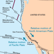
![Map of the west coast of the United States showing the tectonic setting](https://d9-wret.s3.us-west-2.amazonaws.com/assets/palladium/production/s3fs-public/styles/list_item/public/media/images/transform_fault.gif?itok=NAXxQomF)
Transform fault
Transform fault
A special variety of strike-slip fault that accommodates relative horizontal slip between other tectonic elements, such as oceanic crustal plates. Often extend from oceanic ridges.
![Graph with "Distance (Kilometers)" on the x-axis and "Time (Seconds)" on the y-axis with 3 lines plotted. The steepest line is labelled "S-Wave", the middle line is labelled "P-Wave", and the shallowest line is labelled "S-P".](https://d9-wret.s3.us-west-2.amazonaws.com/assets/palladium/production/s3fs-public/styles/list_item/public/media/images/traveltime.gif?itok=BI2-1CvC)
Traveltime curve
Traveltime curve
A graph of arrival times, commonly P or S waves, recorded at different points as a function of distance from the seismic source. Seismic velocities within the earth can be computed from the slopes of the resulting curves.
![Diagram of a right triangle representing land and a blue sqiggly line representing a sea wave](https://d9-wret.s3.us-west-2.amazonaws.com/assets/palladium/production/s3fs-public/styles/list_item/public/media/images/TSUNAMI.gif?itok=01-12ALg)
Tsunami
Tsunami
A sea wave of local or distant origin that results from large-scale seafloor displacements associated with large earthquakes, major submarine slides, or exploding volcanic islands.
![Diagram of a right triangle representing land and a blue sqiggly line representing a sea wave](https://d9-wret.s3.us-west-2.amazonaws.com/assets/palladium/production/s3fs-public/styles/list_item/public/media/images/TSUNAMI.gif?itok=01-12ALg)
Tsunami magnitude (Mt)
The tsunami magnitude, or Mt, is a number used to compare sizes of tsunamis generated by different earthquakes and calculated from the logarithm of the maximum amplitude of the tsunami wave measured by a tide gauge distant from the tsunami source.
![Picture showing 3 stages of a tsunami forming and growing](https://d9-wret.s3.us-west-2.amazonaws.com/assets/palladium/production/s3fs-public/styles/list_item/public/media/images/tsunamigenic.jpg?itok=rBTwR-EJ)
Tsunamigenic
Tsunamigenic
Refers to those earthquakes, commonly along major subduction zone plate boundaries such as those bordering the Pacific Ocean, that can generate tsunamis.
![Photo of gray rock outcrop with horizontal cracks and layers](https://d9-wret.s3.us-west-2.amazonaws.com/assets/palladium/production/s3fs-public/styles/list_item/public/media/images/turbidites.jpg?itok=4dIGNdrs)
Turbidites
Turbidites
Sea-bottom deposits formed by massive slope failures. Rivers flowing into the ocean deposit sediments on the continenal shelf and slope. These slopes fail in response to excessive sedimentation load and sometimes earthquake shaking, sending the sediments sliding down to the ocean bottom to create a turbidite. Carbon dating of turbidites has been shown to provide a good method to determine the date of very old earthquakes.
V
![Three graphs with the x-axis labelled "Time (s)": the first labelled "Acceleration (cm/s^2)," the second labelled "Velocity (cm/s)," and the third labelled "Displacement (cm)."](https://d9-wret.s3.us-west-2.amazonaws.com/assets/palladium/production/s3fs-public/styles/list_item/public/media/images/acceleration%20velocity%20displacement.gif?itok=SmrrvJHb)
Velocity
Velocity
How fast a point on the ground is shaking as a result of an earthquake.
![Graph with "Velocity (km/s)" on the x-axis and "Depth (km)" on the y-axis. There is a large colorful shape plotted with layers of different colors.](https://d9-wret.s3.us-west-2.amazonaws.com/assets/palladium/production/s3fs-public/styles/list_item/public/media/images/velocity_struct.gif?itok=MtfWY7aK)
Velocity structure
Velocity structure
A generalized regional model of the earth's crust that represents crustal structure using layers having different assumed seismic velocities.
W
![Block diagram with a labelled earthquake source shown as a circle on the fault plane and directly underneath the center of the produced circular, seismic waves](https://d9-wret.s3.us-west-2.amazonaws.com/assets/palladium/production/s3fs-public/styles/list_item/public/media/images/SOURCE.gif?itok=1T2Eahlk)
Wavefront
Wavefront
The instantaneous boundary between the seismic waves in the earth material, and the material that the seismic energy has not yet reached.
![Black background with a green wave and a white arrow pointing across one concave and one convex hump to indicate a period](https://d9-wret.s3.us-west-2.amazonaws.com/assets/palladium/production/s3fs-public/styles/list_item/public/media/images/PERIOD.gif?itok=jQbBQIrY)
Wavelength
Wavelength
The distance between successive points of equal amplitude and phase on a wave (for example, crest to crest or trough to trough).
Y
![A figure with text titled "Years before present (YBP)". The text is: "Formation of Earth: 4.6x10^9 YBP. Dinosaur extinction: 6.5x10^7 YBP. First hominids: 2x10^6 YBP. Last great ice age: 1x10^4 YBP. Declaration of Independence: 2x10^2 YBP. Establishment of UWB: 1x10 YBP."](https://d9-wret.s3.us-west-2.amazonaws.com/assets/palladium/production/s3fs-public/styles/list_item/public/media/images/YBP.gif?itok=SiLwBOdB)
YBP
YBP
Abbreviation for "years before present".