

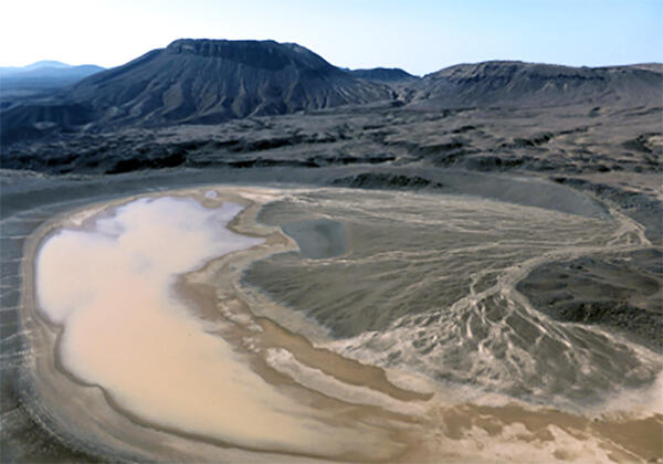
The Kafrein Dam captures runoff from Jordan River side valley wadis, near the Dead Sea, Jordan. USGS hosted a field trip that included a stop at the dam in February, 2017 during a regional workshop on aquifer storage & recovery in the Middle East and North Africa (MENA) region, in cooperation with the U.S. Agency for International Development.
Middle East
Dasht-e Kevir (Great Salt Desert), Iran
Wasteland composed of mud and salt marshes covered with crusts of salt
Wasteland composed of mud and salt marshes covered with crusts of salt
Arabian Sea coast in the Dhofar region, Oman
Difference in climate with lush, fertile areas along the coast separated from the arid interior
Difference in climate with lush, fertile areas along the coast separated from the arid interior
Rub' al Khali (Empty Quarter), border between Saudi Arabia and Yemen
Immense sand deserts, or sand seas in the area are the largest desert of this type in the world
Immense sand deserts, or sand seas in the area are the largest desert of this type in the world
Science in Support of Natural Resource Sustainability, Economic Development and Good Governance
The USGS has a long history of cooperative science with partners in the Middle East, most notably long-term programs in Saudi Arabia (1963-2003), the UAE (1988-2016) and Jordan (1960s through early 2000s). The USGS also had a long-term science diplomacy partnership with UNESCO (1993-2019), the Reduction of Earthquake Loss in the Extended Mediterranean Region (RELEMR) program which brought Arab and Israeli seismologists and earthquake engineers together to better understand and mitigate earthquake hazards in the Middle East and North Africa region.
Currently, the USGS has cooperative agreements in-force with institutions in Iraq, Israel, Jordan, Kuwait, Saudi Arabia, Turkey and the UAE and have active projects in Iraq.
Following are short descriptions and links to recent and on-going USGS cooperative science projects and other activities in and related to the Middle East.
WATER RESOURCES
(Supporting Water, Food Security, Climate Resilience)
Iraq Water
Remote-sensing based investigations are being used to monitor meteorological and hydrologic conditions of the headwaters region of the Tigris and Euphrates Rivers. This information is used by our Iraqi partners to negotiate transboundary water agreements with Turkey and Syria and to manage transboundary flow and reservoir inventories.
Managed Aquifer Recharge in the Middle East and North Africa Region
The USGS led a 5-year regional project to develop and apply methods for water availability and suitability mapping for managed aquifer recharge (MAR) in the Middle East and North Africa region. A regional model of surface runoff for the period from 1984 to 2015 was developed to characterize water availability using remote sensing data on climate, vegetation, and topography in Jordan, Lebanon, and surrounding areas. Surface runoff was accumulated to characterize potential streamflow available for MAR and these data were combined with land surface slope to prepare a regional screening map of MAR suitability, illustrating suitability mapping concepts and methods.
Media

Sources/Usage: Public Domain. View Media Details
ENERGY AND MINERAL RESOURCES
(Supporting Transparency, Good Governance, and Economic Development)
Global Oil and Gas Assessments
The USGS assesses potential for undiscovered conventional and unconventional oil and gas resources in priority geologic provinces throughout the World. In the Middle East, the most recent assessments include those for:
The Zagros Fold Belt of Iran, Iraq, Syria, and Turkey, 2023
The Eastern Mediterranean, 2020
The Jurassic Shales of the Eastern Arabian Peninsula, 2019
The Lower Silurian Shales of the Arabian Peninsula, 2019
Mineral Commodity Information and Supply Chain Studies
The USGS National Minerals Information Center produces annual Mineral Industry Surveys for Middle East countries that are designed to provide timely statistical data on mineral commodities in each country. These can be accessed from the Minerals Yearbook Volume III: Area Reports-International-Africa and the Middle East. Each report includes sections on government policies and programs, environmental issues, trade and production data, industry structure and ownership, commodity sector developments, infrastructure, and a summary outlook.
NATURAL HAZARDS
(Supporting Disaster Risk Reduction)
Earthquake Hazards
The USGS Earthquake Hazards Assistance Team (EDAT) responded to the February 2023 Turkey-Syria Earthquake. EDAT has supported efforts to document earthquake surface rupture, monitor and characterize landslide hazards triggered by the earthquakes and aftershocks, and identify and document structural performance of well-designed mid- and high-rise reinforced concrete frames. The USGS EDAT has also provided capacity building on structural health monitoring activities, aftershock forecasting and assessed fault and shaking hazard to develop informed guidance for mitigation of future earthquakes using dense nodal seismic network and aftershock recordings.
Volcanic Hazards
USGS volcanic hazard studies, in cooperation with the Saudi Geological Survey, have been ongoing in the Cenozoic volcanic fields of western Saudi Arabia for many years. These have included studies related to dike emplacement in the Harrat Lunayyir volcanic field and in the Northern Harrat Rahat volcanic field, in the vicinity of the city of Madinah. The Northern Harrat Rahat project resulted in a comprehensive publication summarizing the science that informed the volcanic hazard assessment.
Media

Sources/Usage: Public Domain. View Media Details
Global Seismographic Network (GSN)
Formed in partnership among the USGS, the National Science Foundation (NSF) and EarthScope, the GSN provides near-uniform, worldwide monitoring of the Earth, with approximately 150 modern seismic stations distributed globally. GSN stations are operated by the USGS Albuquerque Seismological Laboratory, EarthScope, and other affiliate organizations. Data from the GSN are archived at the IRIS Data Management Center.
Within the Middle East, GSN stations are located in Saudi Arabia and the United Arab Emirates.
Related
Accelerating Aquifer Storage & Recovery in the Middle East and North Africa Region
In cooperation with the U.S. Agency for International Development, USGS helped regional partners assess the suitability for managing scarce groundwater resources, and improving water supply, using artificial recharge methods.

Kafrein reservoir captures runoff near the Dead Sea, Jordan
The Kafrein Dam captures runoff from Jordan River side valley wadis, near the Dead Sea, Jordan. USGS hosted a field trip that included a stop at the dam in February, 2017 during a regional workshop on aquifer storage & recovery in the Middle East and North Africa (MENA) region, in cooperation with the U.S. Agency for International Development.

Kafrein reservoir, Jordan
Kafrein reservoir captures runoff in the lower Jordan Valley, near the Dead Sea, Jordan.
Kafrein reservoir captures runoff in the lower Jordan Valley, near the Dead Sea, Jordan.

Spring flow towards the Dead Sea, Jordan
Photo of low-flow conditions in a wadi (stream) along the Jordan Rift Valley. Springflow generated by groundwater discharge at higher elevations eventually flows into the hypersaline Dead Sea.
Photo of low-flow conditions in a wadi (stream) along the Jordan Rift Valley. Springflow generated by groundwater discharge at higher elevations eventually flows into the hypersaline Dead Sea.
Um Junb lava dome, western Saudi Arabia
View south-southwest across maar crater of Gura 1 toward benmoreite lava dome and flow of Um Junb. Trachytic pyroclastic flow deposits of Gura 2 enter from upper right, mantling mugearite lava flow of Dabaa 1. Maar crater is about 0.7 kilometers across, and Um Junb stands about 250 meters above surroundings.
View south-southwest across maar crater of Gura 1 toward benmoreite lava dome and flow of Um Junb. Trachytic pyroclastic flow deposits of Gura 2 enter from upper right, mantling mugearite lava flow of Dabaa 1. Maar crater is about 0.7 kilometers across, and Um Junb stands about 250 meters above surroundings.

Well-withdrawal footprint map, Azraq Oasis, Jordan
Large groundwater withdrawals in the Azraq Oasis area, Jordan, have contributed to declining water levels in wells. This map shows the withdrawal footprint and observed water-level trends (labeled triangular symbols, from Goode et al. 2013).
Large groundwater withdrawals in the Azraq Oasis area, Jordan, have contributed to declining water levels in wells. This map shows the withdrawal footprint and observed water-level trends (labeled triangular symbols, from Goode et al. 2013).

Measuring groundwater levels in a well in Jordan
Groundwater level data are useful for managing aquifers used for water supply.
Groundwater level data are useful for managing aquifers used for water supply.
Related
Accelerating Aquifer Storage & Recovery in the Middle East and North Africa Region
In cooperation with the U.S. Agency for International Development, USGS helped regional partners assess the suitability for managing scarce groundwater resources, and improving water supply, using artificial recharge methods.
Kafrein reservoir captures runoff near the Dead Sea, Jordan
The Kafrein Dam captures runoff from Jordan River side valley wadis, near the Dead Sea, Jordan. USGS hosted a field trip that included a stop at the dam in February, 2017 during a regional workshop on aquifer storage & recovery in the Middle East and North Africa (MENA) region, in cooperation with the U.S. Agency for International Development.
The Kafrein Dam captures runoff from Jordan River side valley wadis, near the Dead Sea, Jordan. USGS hosted a field trip that included a stop at the dam in February, 2017 during a regional workshop on aquifer storage & recovery in the Middle East and North Africa (MENA) region, in cooperation with the U.S. Agency for International Development.
Kafrein reservoir, Jordan
Kafrein reservoir captures runoff in the lower Jordan Valley, near the Dead Sea, Jordan.
Kafrein reservoir captures runoff in the lower Jordan Valley, near the Dead Sea, Jordan.
Spring flow towards the Dead Sea, Jordan
Photo of low-flow conditions in a wadi (stream) along the Jordan Rift Valley. Springflow generated by groundwater discharge at higher elevations eventually flows into the hypersaline Dead Sea.
Photo of low-flow conditions in a wadi (stream) along the Jordan Rift Valley. Springflow generated by groundwater discharge at higher elevations eventually flows into the hypersaline Dead Sea.
Um Junb lava dome, western Saudi Arabia
View south-southwest across maar crater of Gura 1 toward benmoreite lava dome and flow of Um Junb. Trachytic pyroclastic flow deposits of Gura 2 enter from upper right, mantling mugearite lava flow of Dabaa 1. Maar crater is about 0.7 kilometers across, and Um Junb stands about 250 meters above surroundings.
View south-southwest across maar crater of Gura 1 toward benmoreite lava dome and flow of Um Junb. Trachytic pyroclastic flow deposits of Gura 2 enter from upper right, mantling mugearite lava flow of Dabaa 1. Maar crater is about 0.7 kilometers across, and Um Junb stands about 250 meters above surroundings.
Well-withdrawal footprint map, Azraq Oasis, Jordan
Large groundwater withdrawals in the Azraq Oasis area, Jordan, have contributed to declining water levels in wells. This map shows the withdrawal footprint and observed water-level trends (labeled triangular symbols, from Goode et al. 2013).
Large groundwater withdrawals in the Azraq Oasis area, Jordan, have contributed to declining water levels in wells. This map shows the withdrawal footprint and observed water-level trends (labeled triangular symbols, from Goode et al. 2013).
Measuring groundwater levels in a well in Jordan
Groundwater level data are useful for managing aquifers used for water supply.
Groundwater level data are useful for managing aquifers used for water supply.