
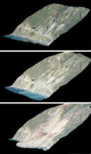
3D maps of air photos show views from before and after the landslide

Detailed Description
Topographic “point clouds” (or 3D maps) created by computer processing of air photos show what the Mud Creek area looked like on March 8, 2017 (top), May 19 (center), and May 27 (bottom).
Sources/Usage
Public Domain.