
3D view of a seismic profile draped under bathymetry

Detailed Description
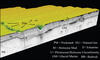
A sub-bottom profile of CHIRP seismic data is draped over swath bathymetry showing the Gulf of Maine pockmark field stratigraphy common to the area. Seafloor mapping combined with sub-bottom geologic profiles shows that Holocene mud ranges in thickness between 5 and 10 meters but pockmarks in Belfast Bay do not penetrate below the geologic unconformity. The approximate distance between the east and west extent of image is 1200 m.
Sources/Usage
Public Domain.