
Aerial image and satellite derived image of Florida Lakes

Detailed Description
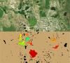
This image is a cropped rendition of two aerial images that demonstrate satellite-derived cyanobacteria concentrations in surface waters from an area in Florida. The top image is true-color photograph, and the bottom image is from the Medium Resolution Imaging Spectrometer (MERIS) sensor on the Envisat satellite, taken October 1, 2011. Data from the sensor lets scientists assign quantitative values for cyanobacteria concentrations, which are represented using a color scale ranging from blue (low concentrations) to red (high concentrations).
Details
Image Dimensions: 2234 x 4000
Sources/Usage
Public Domain.