
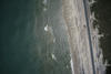
Aerial image from post-Hurricane Isaias of North Carolina coast

Detailed Description
The USGS Remote Sensing Coastal Change Project collected aerial imagery of the northern Outer Banks, North Carolina coastline from pre- and post-Hurricane Isaias, in order to use Structure-from-Motion techniques to produce digital elevation models (DEMs) and orthomosaic photos, to be used in evaluating the storm-induced coastal change, such as sand transported onto roadways that is being removed in this post-storm photo.
Sources/Usage
Public Domain.