
CoSMoS map of San Francisco
By Communications and Publishing
2017 (approx.)

Detailed Description
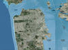
Example of CoSMoS projection displayed in the Our Coast, Our Future (OCOF) online tool.
Sources/Usage
Public Domain.
Our Coast, Our Future
Our Coast, Our Future (OCOF) is a collaborative, user-driven project focused on providing coastal California resource managers and land use planners locally relevant, online maps and tools to help understand, visualize, and anticipate vulnerabilities to sea level rise and storms.