
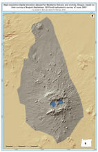
Digital Elevation Model for Newberry Volcano and vicinity.
By Volcano Hazards Program
2016 (approx.)

Detailed Description
High-resolution digital elevation dataset for Newberry Volcano and vicinity, Oregon, based on lidar survey of August-September, 2010 and bathymetric survey of June, 2001.
Sources/Usage
Public Domain.