
Dorian NOAA imagery pairs: Location 1
By St. Petersburg Coastal and Marine Science Center
2019 (approx.)

Detailed Description
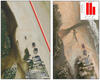
A breach which first opened during Hurricane Matthew re-opened during Hurricane Dorian due to elevated water levels and large storm waves that overwashed and flooded a low-lying section of the coast. The predicted probability of inundation was 60% for this location.
Sources/Usage
Public Domain.