
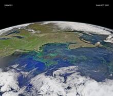
Enhanced VIIRS Satellite Image of Gulf of Maine, 14 May 2015

Detailed Description
Data from the Visible Infrared Imaging Radiometer Suite (VIIRS) sensor on the Suomi NPP satellite was used to create this enhanced color composite image of the Gulf of Maine and the northwestern Atlantic Ocean on May 14, 2015. Light green colors indicate areas where water conditions and nutrients near the surface (including dissolved organic carbon) create phytoplankton blooms. (credit: Norman Kuring, NASA Ocean Color Group)
Huntington et al. (2016) reported increasing export of dissolved organic carbon (DOC) to the Gulf of Maine in the latter half of the 20th and early 21st centuries and discussed projections for increasing DOC export in the 21st century based on climate projections. Huntington et al. (2016) suggested that increasing DOC export to the near coastal ocean may influence marine biogeochemistry including the development of nuisance and harmful algal blooms and carbon sequestration. In the near‐coastal ocean, colored dissolved organic matter (CDOM), which is a component of terrestrially derived DOC, can lower the accuracy of satellite‐derived chlorophyll concentrations. CDOM strongly absorbs in the blue wavelengths, thus lowering the water‐leaving radiance in those wavelengths that the satellite sensor's chlorophyll algorithm mistakenly interprets as chlorophyll absorption. Terrestrially derived DOC exported to the marine environment could also decrease phytoplankton productivity through increases in light attenuation (Balch et al. 2012, Balch et al. 2016).
Cited References
- Balch, W. M., Drapeau, D. T., Bowler, B. C., and Huntington, T. G., (2012) Step-changes in the physical, chemical and biological characteristics of the Gulf of Maine, as documented by the Gulf of Maine North Atlantic Time Series (GNATS); Marine Ecological Progress Series, v. 450, p. 11-35.
- Balch, W. M., Huntington, T. G., Aiken, G R. Drapeau, D, Bowler, B., Lubelczyk, L. and Butler, Kenna, (2016) Toward a quantitative and empirical dissolved organic carbon budget for the Gulf of Maine, a semi-enclosed shelf sea; Global Biogeochemical Cycles, v. 30 p. 268-292.
- Huntington, T. G., W. M. Balch, G. R. Aiken, J. Sheffield, L. Luo, C. S. Roesler, and P. Camill, (2016) Climate change and dissolved organic carbon export to the Gulf of Maine; Journal of Geophysical Research; Biogeosciences, v. 121, p. 2700-2716.
Sources/Usage
Credit: Norman Kuring, NASA Ocean Color Group