
Figure 1 for Southwestern Willow Flycatcher Habitat Viewer webpage

Detailed Description
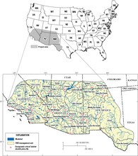
Figure 1. Maps showing location of the project area and the 35 U.S. Fish and Wildlife Service Southwestern Willow Flycatcher management unit boundaries, designated critical-habitat reaches, and waterbodies considered by the satellite model for regionwide modeling, Southwestern United States.
Sources/Usage
Public Domain.
U.S. Geological Survey Open-File Report 2016–1120, 88 p.
Hatten, J.R., 2016, A satellite model of Southwestern Willow Flycatcher (Empidonax traillii extimus) breeding habitat and a simulation of potential effects of tamarisk leaf beetles (Diorhabda spp.), Southwestern United States: U.S. Geological Survey Open-File Report 2016–1120, 88 p.