
Figure 6 for Southwestern Willow Flycatcher Habitat Viewer webpage

Detailed Description
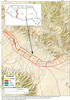
Figure 6. Map showing changes in predicted flycatcher habitat along the upper Gila River after conducting a tamarisk leaf beetle-impact simulation. The upper Gila River was divided into nine zones in order to quantify changes. A satellite model was used to predict flycatcher habitat at a 40-percent probability threshold.
Sources/Usage
Public Domain.
U.S. Geological Survey Open-File Report 2016–1120, 88 p.
Hatten, J.R., 2016, A satellite model of Southwestern Willow Flycatcher (Empidonax traillii extimus) breeding habitat and a simulation of potential effects of tamarisk leaf beetles (Diorhabda spp.), Southwestern United States: U.S. Geological Survey Open-File Report 2016–1120, 88 p.