
GFSAD30 Figure C1

Detailed Description
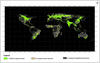
An aggregated three class global cropland extent map at nominal 1-km based on four major studies: Thenkabail et al. (2009a, 2011), Pittman et al. (2010), Yu et al. (2013) and Friedl et al. (2010). Class 1 is total cropland extent based on pixels with 100% cropland cover (2.3 billion hectares). Class2 and Class3 have minor fractions of croplands.
Sources/Usage
Courtesy: Dr. Prasad Thenkabail