
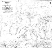
Henry Elliott’s 1871 map of Yellowstone Lake
By Yellowstone Volcano Observatory
1871 (approx.)

Detailed Description
Henry Elliott’s 1871 map of Yellowstone Lake (https://hdylake.org/about/history-of-mapping-yellowstone-lake/). The headwaters of the Snake River, Upper Valley of the Yellowstone River, and Pelican River are shown. The area now known as West Thumb is referred to as the South West Arm on the map. About 300 lead-sink soundings of lake depth were taken in this survey; most locations where soundings were obtained are marked on this map (depth in feet). Also shown are several of the places where the Hayden survey camped as they traversed around Yellowstone Lake.
Sources/Usage
Public Domain.