
Hurricane Delta flood and storm tracker map

Detailed Description
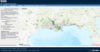
This flood and storm tracker map shows areas Hurricane Delta may have spread nonindigenous aquatic species. Hurricane Delta made landfall in Louisiana in October, 2020. USGS image.
Sources/Usage
Public Domain.