
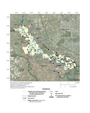
Hurricane Harvey flood-inundation map of upper Brazos River
By Communications and Publishing
2018 (approx.)

Detailed Description
Flood-inundation map of the upper reach of the Brazos River for the August and September 2017 Hurricane Harvey-related flood event in southeastern Texas and southwestern Louisiana.
Sources/Usage
Public Domain.