
Illinois River Basin low-level flight overview

Detailed Description
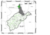
This map shows the airborne geophysical survey area and planned flight paths across the Illinois River Basin in Illinois and northwest Indiana. Surveys will not occur directly above populated areas. Planned flight lines and survey progress can be found online.
(USGS map)
Sources/Usage
Public Domain.