
Kīlauea caldera gas mapping—August 10, 2021

Detailed Description
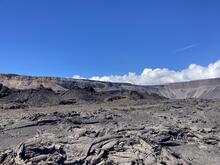
Spatter ramparts from the April 30, 1982, Kīlauea summit eruption remain visible on the floor of Kīlauea caldera. During this brief eruption, which lasted approximately 19 hours, lava erupted from a 1-km-long (0.6 mile) fissure that extended to the northeast of Halema‘uma‘u. Part of the 1982 spatter rampart collapsed into Halema‘uma‘u during the 2018 Kīlauea summit collapse events, but much of it remains intact. USGS photo by K. Mulliken on August 10, 2021.
Sources/Usage
Public Domain.