Landsat View of Erta Ale Eruption

Detailed Description
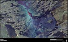
In this view of Ethiopia’s Erta Ale, taken on January 10, 2017, Landsat shows lava welling up in the caldera. Credit: USGS/NASA Landsat Program.
Sources/Usage
Public Domain.

Official websites use .gov
A .gov website belongs to an official government organization in the United States.
Secure .gov websites use HTTPS
A lock () or https:// means you’ve safely connected to the .gov website. Share sensitive information only on official, secure websites.
In this view of Ethiopia’s Erta Ale, taken on January 10, 2017, Landsat shows lava welling up in the caldera. Credit: USGS/NASA Landsat Program.
Public Domain.