
LCMAP CONUS V13_Release

Detailed Description
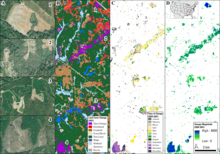
(A) U.S. Department of Agriculture (USDA) National Agriculture Imagery Program (NAIP) aerial imagery from November 15, 2021 over recently disturbed locations near Newnan, Georgia, located southwest of Atlanta. Examples include what appear to be (1) forest clearing for urban development, (2) part of a tornado scar from an EF4 tornado that struck Newnan on March 26, 2021, (3) a combination of disturbances including reforestation, and (4) forest harvest. (B) LCMAP Collection 1.3 Annual Land Cover Change from 2021 identified all four disturbances, shown in purple as land cover classification changes. (C) The LCMAP Collection 1.3 Time of Spectral Change product from 2020 and 2021 shows when spectral changes occurred in 2020 and 2021, grouped by month, including the tornado scar showing changes in April 2021 after the late March tornado. (D) The LCMAP Collection 1.3 Spectral Change Magnitude product, which shows the intensity of a spectral model break, with more drastic changes such as forest clearing in shades of blue and more subtle changes like forest regrowth or tornado damage in shades of green.
Sources/Usage
Public Domain.