
Lidar-derived digital surface and elevation models of a stream channel

Detailed Description
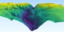
The above image is a rendering of a lidar-derived digital surface model overlaying a digital elevation model of a forested stream channel in central Iowa. The vegetation makes optical identification of the presence of water in channels difficult. The digital models are being used to measure the structure of vegetation adjacent to channels in an attempt to identify features that indicate the presence of surface water.
Sources/Usage
Public Domain.