
lidar point cloud vs. bare earth DEM
By Frequently Asked Questions
2018 (approx.)

Detailed Description
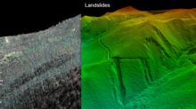
By processing lidar point clouds (left) to bare earth DEMs (right), the vegetation is stripped away to reveal past landslides and steep slopes at risk of failure masked by forested canopies. In dense forests, landslides--especially old landslides--might be invisible on aerial images and hard to detect from the ground.
Sources/Usage
Public Domain.