
Long-term drought at Lake Mead on the Colorado River
Detailed Description
Lake Mead is the largest reservoir in the United States and part of a system that supplies water to at least 40 million people across seven states and northern Mexico. It stands today at its lowest level since Franklin Delano Roosevelt was president. This means less water will be portioned out to some states in the 2022 water year.
As of August 22, 2021, Lake Mead was filled to just 35 percent of its capacity. The low water level comes at a time when 95 percent of the land in nine Western states is affected by some level of drought (64 percent is extreme or worse). It continues a 22-year megadrought that may be the region’s worst dry spell in twelve centuries.
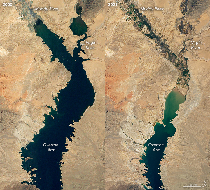
These natural-color images were acquired in August 2000 and August 2021 by Landsat 7 and Landsat 8. The tan fringes along the shoreline in 2021 are areas of the lakebed that would be underwater when the reservoir is filled closer to capacity. The phenomenon is often referred to as a “bathtub ring.”
The lake elevation data below come from the U.S. Bureau of Reclamation, which manages Lake Mead, Lake Powell, and other portions of the Colorado River watershed. At the end of July 2021, the water elevation at the Hoover Dam was 1067.65 feet (325.4 meters) above sea level, the lowest since April 1937, when the lake was still being filled. The elevation at the end of July 2000—around the time of the Landsat 7 images above and below—was 1199.97 feet (365.8 meters).
acquired August 7, 2000 - August 9, 2021
For the 2022 water year, which begins October 1, Mexico will receive 80,000 fewer acre-feet, approximately 5 percent of the country’s annual allotment and Nevada’s take will be cut by: 21,000 acre-feet (about 7 percent of the state’s annual apportionment). The biggest cuts will come to Arizona, which will receive 512,000 fewer acre-feet, approximately 18 percent of the state’s annual apportionment and 8 percent of the state’s total water use (for agriculture and human consumption). An acre-foot is enough water to supply one to two households a year.
Sources/Usage
Public Domain.
Source: USGS/NASA Landsat, 2000 and 2021. Public domain.
Acquired August 7, 2000 - August 9, 2021