
Madeira Beach Camera Time Series

Detailed Description
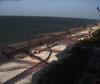
This photo is the results of processing a time series of images, which are a combination of all image frames collected during a 10 to 17-minute video. These images are incredibly useful for studying coastal change remotely, but the usefulness of the image depends on how they are processed. This image represents an image with only the darkest pixels displayed from each moment. By using this method, the white caps of the waves are essentially removed from the picture and allow us to “see” objects underwater.
From these images, we can see coastal features and hazards such as changes in shoreline position, both seasonally and due to long-term effects such as sea-level rise; the presence and shape of offshore sandbars; and the occurrence of rip currents and erosion during extreme storm events. Changes in these features through time provide valuable insight into the dynamic nature of coastal environments. These images are used to create and test computer models which are used by the USGS to assess vulnerability of our coasts to coastal hazards.
Learn more about our coast cameras.
Sources/Usage
Public Domain.