
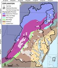
Map of 68 field sites and their upstream drainage areas of the Chesapeake and Delaware watersheds

Detailed Description
Map of 68 field sites and their upstream drainage areas of the Chesapeake and Delaware watersheds, located in the U.S. Mid-Atlantic region. The sites were chosen to sample the regional landscape variation in watersheds and streams.
Sources/Usage
Public Domain.