
Map of June 27th flow in Kīlauea's ERZ

Detailed Description
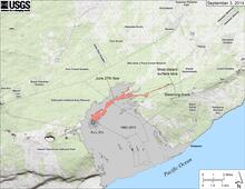
Map showing the June 27th flow in Kīlauea's East Rift Zone as of September 3, 2014. The area of the flow as mapped on September 1 is shown in pink, while widening and advancement of the flow as of September 3 is shown in red. Last night, lava welled up out of the crack it was filling and spilled out onto the ground to feed new surface flows. As of early afternoon today (September 3), lava on the surface was 13.2 km (8.2 miles) from the vent and 1.3 km (0.8 miles) from the east boundary of the Wao Kele o Puna Forest Reserve. All older lava flows (1983-2014) are shown in gray; the yellow line marks the lava tube.
Sources/Usage
Public Domain.