
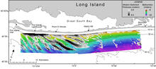
Map showing Holocene (modern) sediment thickness
By Woods Hole Coastal and Marine Science Center
2011 (approx.)

Detailed Description
Map showing Holocene (modern) sediment thickness in meters overlain on bathymetry. Regional bathymetric contours are in meters. Note the shoreface-attached sand ridges west of Watch Hill.
Sources/Usage
Public Domain.
Related

Coastal Change Processes- Fire Island, NY
Fire Island, a 50-km long barrier-island system between Fire Island Inlet and Moriches Inlet, attracts significant tourism, includes federal, state, and county parks, contains a number of coastal communities, provides storm damage protection to the adjacent heavily populated mainland, and supports a distinct barrier island ecosystem, all of which are affected by coastal change. Mitigating the...
Related
Coastal Change Processes- Fire Island, NY
Fire Island, a 50-km long barrier-island system between Fire Island Inlet and Moriches Inlet, attracts significant tourism, includes federal, state, and county parks, contains a number of coastal communities, provides storm damage protection to the adjacent heavily populated mainland, and supports a distinct barrier island ecosystem, all of which are affected by coastal change. Mitigating the...