
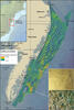
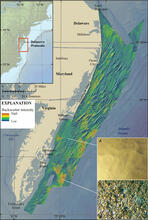
Map shows hill-shaded bathymetric, backscatter, and photographic data
By Coastal and Marine Hazards and Resources Program
2017 (approx.)

Detailed Description
Hill-shaded bathymetric, backscatter, and photographic data collected by NOAA and the USGS. Backscatter data give indications of seafloor character. In general, low-backscatter intensity (blue) corresponds to finer-grained material, whereas high-backscatter intensity (orange) corresponds to coarser substrate. Off the coast of Virginia, zones of low backscatter indicate a smoother, sandy sea floor (inset A), whereas zones of high backscatter often indicate a sea floor with abundant carbonate (shell hash) (inset B).
Sources/Usage
Public Domain.