
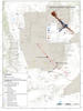
Map Shows Seismic and GPS Deployments near Ridgecrest as of July 11

Detailed Description
Seismic instruments and GPS deployments as of July 11, 2019. Seismic stations are indicated by triangles and GPS stations are shown as squares. Preliminary mapping of surface ruptures from the July 4 magnitude 6.4 event is shown in black. Ruptures from the July 5 magnitude 7.1 event appear in red.
Sources/Usage
Public Domain.