
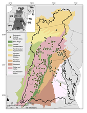
Map of surface water sampling locations in the Chesapeake Bay Watershed
By Chesapeake Bay Activities
December 2022 (approx.)

Detailed Description
Surface water sampling locations (n = 244) in the Chesapeake Bay Watershed shown with EPA Level 3 Ecoregions.
Sources/Usage
Public Domain.