
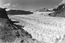
Muir and Riggs Glaciers, Muir Inlet, Alaska - 1941

Detailed Description
This northeast-looking photograph, on the southeastern side of White Thunder Ridge ,shows the lower reaches of Muir Glacier, then a large tidewater calving valley glacier, and its tributary Riggs Glacier. The séracs in the lower right-hand corner of the photograph mark Muir Glacier’s terminus. The ice thickness is more than 700 meters. Muir Glacier had been retreating since the mid-eighteenth century, with maximum retreat exceeding 50 kilometers. In places, more than a kilometer thickness of ice had been lost. Note the absence of vegetation and the bare bedrock faces present on both sides of the glacier. (W.O. Field)
Sources/Usage
Public Domain.