
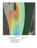
Multibeam sonar depth map

Detailed Description
Multibeam sonar depth map showing sand dunes and locations of reproductive female code 41 and multiple male pallid sturgeons from June 13 to June 15, 2015 during a presumed spawning event near Fairview, North Dakota.
Sources/Usage
Public Domain.