
(outdated) Map for Integrated Water Availability Assessments (IWAAs)

Detailed Description
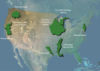
Project area map for the Integrated Water Availability Assessments (IWAAs), including the Mississippi Alluvial Plain pilot and projects using Cooperative Matching Funds. This map represents 2019 projects and is not current.
Sources/Usage
Public Domain.