
Rincon Point
By Pacific Coastal and Marine Science Center
2015 (approx.)

Detailed Description
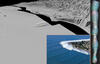
Gray-scale perspective view of Rincon Point, the subaerial part of a delta formed by boulders deposited at the mouth of Rincon Creek. A relict submerged boulder delta, formed by similar processes during lower stands of sea level, extends 1,500 meters offshore. Relief on this submerged delta causes wave refraction and a world-class surfbreak (inset image). Vertical panel on right is a video clip showing the pebble-boulder seafloor on the relict delta; clip's location is shown by yellow line just above red arrow on the grayscale image (easier to see on the larger image, which does not have the arrow).
Sources/Usage
Public Domain.
Related Content

California Seafloor Mapping Program
The California Seafloor Mapping Program (CSMP) is a cooperative program to create a comprehensive coastal and marine geologic and habitat base map series for all of California's State waters.
Related Content
California Seafloor Mapping Program
The California Seafloor Mapping Program (CSMP) is a cooperative program to create a comprehensive coastal and marine geologic and habitat base map series for all of California's State waters.