
Salton Sea, California, USA

Detailed Description
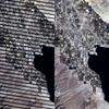
This image is an example of a Gap-Filled product. The left image is path 39 row 37, acquired over the Salton Sea in southern California on September 17, 2003; the image shows the scan gaps caused by the failed Scan Line Corrector (SLC).
Sources/Usage
Public Domain.