
Satellite-Derived Bathymetry

Detailed Description
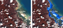
DigitalGlobe WorldView imagery of Kāne‘ohe Bay, Oahu (left image) (coastal, blue, and green bands). Estimates of satellite-derived bathymetry of Kāne‘ohe Bay, Oahu (right, light blue is shallow). Images created by Sandra Poppenga.
Sources/Usage
Public Domain.