
Screenshot of FDST webmap showing waterbody footprint of Lake Houston

Detailed Description
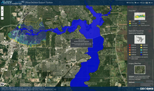
Screenshot of FDST webmap showing waterbody footprint of Lake Houston.
Reservoir conditions across Texas can be found under “Observation Stations.” A color-coded status of lake/reservoir conditions is displayed and an explanation of the colors is available in the legend. A map of current reservoir conditions for a lake and a modeled flood inundation area from a nearby stream are shown in this image.
Sources/Usage
Public Domain.