
Seafloor trace of the Queen Charlotte-Fairweather fault
By Pacific Coastal and Marine Science Center
2015 (approx.)

Detailed Description
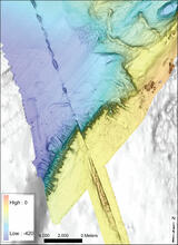
Seafloor trace of the Queen Charlotte-Fairweather fault (from top left to bottom right) offsets the edge of the Yakobi Sea Valley off southeast Alaska. This 700-mile-long fault has generated large earthquakes in the past. Future shocks—and tsunamis—could threaten coastal communities in the U.S. and Canada. (Color-coded depths, in meters, were mapped in 2015.)
Sources/Usage
Public Domain.
Related Content

Earthquake Hazards in Southeastern Alaska
Over the last 100 years, the Queen Charlotte-Fairweather fault system has produced large-magnitude earthquakes affecting both Canada and the U.S. To fill in missing details about its offshore location and structure, USGS uses sophisticated techniques to truly understand the fault’s hazard potential.

Coastal and Marine Geohazards of the U.S. West Coast and Alaska
Coastal and marine geohazards are sudden and extreme events beneath the ocean that threaten coastal populations. Such underwater hazards include earthquakes, volcanic eruptions, landslides, and tsunamis.
By
Natural Hazards Mission Area, Coastal and Marine Hazards and Resources Program, Pacific Coastal and Marine Science Center, 3-D CT Core Imaging Laboratory, Core Preparation and Analysis Laboratory and Sample Repositories, Big Sur Landslides, Deep Sea Exploration, Mapping and Characterization, Subduction Zone Science
Related Content
Earthquake Hazards in Southeastern Alaska
Over the last 100 years, the Queen Charlotte-Fairweather fault system has produced large-magnitude earthquakes affecting both Canada and the U.S. To fill in missing details about its offshore location and structure, USGS uses sophisticated techniques to truly understand the fault’s hazard potential.
Coastal and Marine Geohazards of the U.S. West Coast and Alaska
Coastal and marine geohazards are sudden and extreme events beneath the ocean that threaten coastal populations. Such underwater hazards include earthquakes, volcanic eruptions, landslides, and tsunamis.
By
Natural Hazards Mission Area, Coastal and Marine Hazards and Resources Program, Pacific Coastal and Marine Science Center, 3-D CT Core Imaging Laboratory, Core Preparation and Analysis Laboratory and Sample Repositories, Big Sur Landslides, Deep Sea Exploration, Mapping and Characterization, Subduction Zone Science