
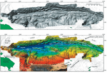
Shaded relief and combined bathymetry map of Puerto Rico

Detailed Description
(Top image) Shaded relief of the new multibeam bathymetry along the Puerto Rico Trench illuminated from the northwest. Thin contours indicate bathymetry at 500-m intervals. (Bottom image) Combined bathymetry map of the multibeam bathymetry data, single-beam bathymetry compilation around Puerto Rico, Lidar data near shore, and topography of Puerto Rico. Contour interval is 500 m. Thick barbed white lines denote thrust faults; thick white lines denote normal faults; thin white line denotes strike-slip fault; thin black line denotes northern edge of tilted carbonate platform and southern edge on land; dashed lines indicate head scarp of slope failures; dotted line indicates debris toe; blue lines indicate fissures in the seafloor; A - pull-apart basin; B - location of probable extinct mud volcano observed on backscatter images. Large box and a grey arrow show location and viewing direction of the figure shown in the tsunami section.
Sources/Usage
Public Domain.