
Snow to Flow.png

Detailed Description
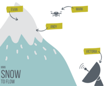
In order to get accurate measurements, the Snow to Flow scientists collect several kinds of data using a few different tools. Evan and the team dig snowpits and collect snow depth, snow density, and weather data. They also place sensors across the snowpack to help the drones collect accurate data. Andy and the team use a tool called ground penetration radar (GPR) to measure snow depth and density. They ski across the snowpack with a sled that holds the GPR system. Mark and the Uncrewed Aircraft System team use two kinds of drone platforms to collect data from the air: one equipped with radar (SDRadar), the other with lidar. Victoria makes maps for the team and ensures that the data is collected accurately and safely.
Sources/Usage
Public Domain.