
Trinidad submarine canyon bathymetry

Detailed Description
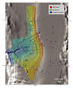
Colored, shaded-relief bathymetry of Trinidad Submarine Canyon northwest of Humboldt Bay in northern California. Area is in the vicinity of a potential offshore renewable energy development. See larger map for location.
Figure 1: EXPRESS surveys, dives, and sampling locations
Figure 2: Trinidad Submarine Canyon bathymetry (this map)
Figure 3: Offshore central California bathymetry
Sources/Usage
Public Domain.