
USGS Figure illustrating Kīlauea’s south flank motion
By Kīlauea
2018 (approx.)

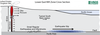
Detailed Description
USGS Figure illustrating Kīlauea’s south flank motion and location of regular earthquakes and aftershocks. The fault depicted in the figure is the detachment fault or décollement. This figure illustrates how the 2018 lower East Rift Zone (LERZ) dike intrusion exerted pressure on the south flank.
Sources/Usage
Public Domain.