
USGS scientist reviews the imagery being acquired from a UAS at the Cimarron Canyon in New Mexico

Detailed Description
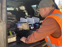
USGS scientist Mark Bauer reviews the imagery being acquired from a UAS at the Cimarron Canyon in New Mexico
Due to the complex nature of mapping vertical faces, NUSO used unique photogrammetric UAS data collection techniques including the use of a stabilized gimbal with vibration dampening that allowed scientists to push smaller lens apertures, achieving a sharply focused set of overlapping images covering a considerable depth-of-field.
NUSO researchers worked with USGS geologists in September 2021 to establish and test unique photogrammetric data collection techniques utilizing UAS along the Paleocene Poison Canyon Formation in the Cimarron Canyon.
Sources/Usage
Public Domain.