
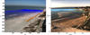
Views of beaches show selected “pixel instruments”
By Coastal and Marine Hazards and Resources Program
2017 (approx.)
Detailed Description
Views of Madeira Beach (left) and Cowells Beach (right) show selected “pixel instruments,” which are sampled continuously during each video and used to estimate different coastal processes. The dots (dark blue on left, light blue on right) represent an array of pixels used for applying the cBathy algorithm to estimate bathymetry. The lines represent cross-shore arrays of pixels used for measuring wave runup, or how high the water reached up the beach.
Sources/Usage
Public Domain.